Login
Register


WVI
Watsonville Municipal Airport
Official FAA Data Effective 2024-04-18 0901Z
Chart Supplement

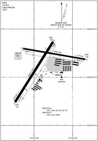
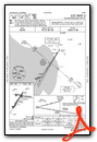
KWVI Airport Diagram
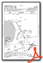
VFR Chart of KWVI
Sectional Charts at SkyVector.com
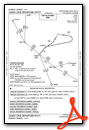
IFR Chart of KWVI
Enroute Charts at SkyVector.com
Location Information for KWVI
Coordinates: N36°56.14' / W121°47.38'Located 03 miles NW of Watsonville, California on 330 acres of land. View all Airports in California.
Surveyed Elevation is 163 feet MSL.
Operations Data
|
|
Airport Communications
| ASOS: | 132.275 Tel. 831-724-8794 |
|---|---|
| NORCAL APPROACH: | 127.15 ;136-360 MRY 307.125 ;136-360 MRY |
| NORCAL DEPARTURE: | 127.15 ;136-360 MRY 307.125 ;136-360 MRY |
| IC: | 127.15 ;136-360 MRY 307.125 ;136-360 MRY |
| UNICOM: | 122.800 |
| CTAF: | 122.800 |
| CLASS C: | 127.15 ;136-360 MRY 307.125 ;136-360 MRY |
| AWOS-3P at E16 (12.6 NE): | 118.350 408-918-7724 |
| AWOS-3PT at OAR (15.3 S): | 134.025 831-384-2967 |
| AWOS-3 at CVH (18.4 E): | 120.425 831-636-4394 |
Nearby Navigation Aids
|
| ||||||||||||||||||||||||||||||||||||||||||


Runway 02/20
| Dimensions: | 4502 x 149 feet / 1372 x 45 meters | |
|---|---|---|
| Surface: | Asphalt in Excellent Condition | |
| Weight Limits: | S-81, D-96, ST-167 | |
| Edge Lighting: | Medium Intensity | |
| Runway 02 | Runway 20 | |
| Coordinates: | N36°55.74' / W121°47.75' | N36°56.37' / W121°47.25' |
| Elevation: | 139.5 | 157.7 |
| Traffic Pattern: | Left | Left |
| Runway Heading: | 32° True | 212° True |
| Displaced Threshold: | 589 Feet | |
| Markings: | Non-Precision Instrument in good condition. | Non-Precision Instrument in fair condition. |
| Glide Slope Indicator | P2L (3.00° Glide Path Angle) | P2L (3.00° Glide Path Angle) UNUSBL BYD 4.0 NM DUE TO TERRAIN. |
| REIL: | Yes | |
| Obstacles: | 46 ft Trees 1310 ft from runway, 39 ft left of center | 80 ft Tree 1198 ft from runway, 125 ft left of center RWY 20 APCH RATIO 22:1 TO DSPLCD THR. |
Runway 09/27
| Dimensions: | 3998 x 98 feet / 1219 x 30 meters | |
|---|---|---|
| Surface: | Asphalt in Fair Condition | |
| Weight Limits: | S-45, D-65 | |
| Runway 09 | Runway 27 | |
| Coordinates: | N36°56.30' / W121°47.64' | N36°56.19' / W121°46.84' |
| Elevation: | 163.3 | 136.3 |
| Traffic Pattern: | Left | Left |
| Runway Heading: | 100° True | 280° True |
| Markings: | Basic in fair condition. | Basic in fair condition. |
| Glide Slope Indicator | P2R (4.00° Glide Path Angle) | |
| Obstacles: | 38 ft Tree 1050 ft from runway | 55 ft Tree 935 ft from runway, 40 ft right of center |
Services Available
| Fuel: | 100LL (blue), Jet-A, UL94 |
|---|---|
| Transient Storage: | Tiedowns |
| Airframe Repair: | MINOR |
| Engine Repair: | MAJOR |
| Bottled Oxygen: | LOW |
| Bulk Oxygen: | NONE |
| Other Services: | AIR AMBULANCE SERVICES,AVIONICS,CHARTER SERVICE,PILOT INSTRUCTION,PARACHUTE JUMP ACTIVITY,AIRCRAFT RENTAL,AIRCRAFT SALES |
Ownership Information
| Ownership: | Publicly owned | |
|---|---|---|
| Owner: | CITY OF WATSONVILLE | |
| 275 MAIN ST | ||
| WATSONVILLE, CA 95076 | ||
| 831-768-3000 | ||
| Manager: | RAYVON WILLIAMS | RAYVON.WILLIAMS@CITYOFWATSONVILLE.ORG |
| 100 AVIATION WAY | ||
| WATSONVILLE, CA 95076 | ||
| 831-768-3575 | ||
Operational Statistics
| Single Engine Aircraft Based on Field: | 256 | Statistics collected for 12 month period ending 2022-06-30 | |
|---|---|---|---|
| Multi-Engine Aircraft Based on Field: | 15 | Annual Commercial Operations: | none |
| Jet Aircraft Based on Field: | 4 | Annual Commuter Operations: | none |
| Helicopters Based on Field: | 5 | Annual Air Taxi Operations: | none |
| Military Aircraft Based on Field: | none | Annual Military Operations: | 30 |
| Gliders Based on Field: | none | Annual GA Local Operations: | 39900 |
| Ultralights Based on Field: | 2 | Annual GA Itinerant Operations: | 20070 |
Other Remarks
- SEAGULLS ON & INVOF ARPT.
- FOR CD CTC NORCAL APCH AT 916-361-3748 OR VIA VHF 127.15.
- ALL DEPS PROHIBITED ON RWY 27 DUE TO RWY VIS BLOCKED BY HNGRS.
- 130 FT TREES 700 FT RIGHT OF RWY 9 THLD, 85 FT TREES 600 FT LEFT OF RWY 9 THLD.
- ARPT HAS NOISE ABATEMENT PROCS; SEE ARPT WEBSITE.
- RWY 20 PREF CALM WIND RWY; STRAIGHT-IN APCH NOT RCMDD.
- GLIDER TOWING RQRS PRIOR NOTIFICATION, CTC ARPT OFC 831-768-3575.
- HELICOPTER ACTVTY ON AND INVOF ARPT.
- COASTAL FOG DURING SUMMER MONTHS.
- PRCHT OPS ON ARPT DLY 0900-2000; LNDG AREA 1000 FT WEST OF RWY 20.
- 94 SELF-SERVICE ONLY.
- ACTVT PAPI RWY 02, 09 & 20; REIL RWY 02; MIRL RWY 02/20 - CTAF.
Weather Minimums
Instrument Approach Procedure (IAP) Charts
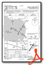
Departure Procedure (DP) Charts
Departure Procedure Obstacles (DPO) Charts
Nearby Airports with Instrument Procedures
| ID | Name | Heading / Distance | ||
|---|---|---|---|---|
 |
E16 | San Martin Airport | 046° | 12.7 |
|
KOAR | Marina Municipal Airport | 174° | 15.3 |
|
KCVH | Hollister Municipal Airport | 097° | 18.4 |
|
KSNS | Salinas Municipal Airport | 151° | 18.6 |
|
KMRY | Monterey Regional Airport | 187° | 21.1 |
|
KRHV | Reid-Hillview of Santa Clara County Airport | 356° | 23.8 |
|
KSJC | Norman Y Mineta San Jose International Airport | 345° | 26.5 |
|
KNUQ | Moffett Federal Airfield Airport | 336° | 31.4 |
|
KPAO | Palo Alto Airport | 333° | 35.1 |
|
KSQL | San Carlos Airport | 327° | 41.0 |
|
KLSN | Los Banos Municipal Airport | 079° | 44.9 |
|
KLVK | Livermore Municipal Airport | 358° | 45.4 |
Airport Images
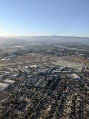
By: stepiko

By: bbt95762


Comments
Approach into Watsonville