Login
Register


X60
Williston Municipal Airport
Official FAA Data Effective 2024-04-18 0901Z
Chart Supplement

VFR Chart of X60
Sectional Charts at SkyVector.com
IFR Chart of X60
Enroute Charts at SkyVector.com
Location Information for X60
Coordinates: N29°21.28' / W82°28.23'Located 02 miles SW of Williston, Florida on 1600 acres of land. View all Airports in Florida.
Surveyed Elevation is 75 feet MSL.
Operations Data
|
|
Airport Communications
| AWOS-3T: | 118.425 Tel. 352-528-9949 |
|---|---|
| JACKSONVILLE APPROACH: | 118.6 251.15 |
| JACKSONVILLE DEPARTURE: | 118.6 251.15 |
| CTAF: | 122.975 |
| UNICOM: | 122.975 |
| AWOS-3PT at OCF (16.9 SE): | 128.125 352-237-8525 |
| ATIS at OCF (16.9 SE): | 128.125 |
| ASOS at GNV (22.7 NE): | 127.15 352-335-8672 |
Nearby Navigation Aids
|
| ||||||||||||||||||||||||||||||||||||||||||||||||||||||


Runway 05/23
| Dimensions: | 6669 x 100 feet / 2033 x 30 meters | |
|---|---|---|
| Surface: | Concrete / Grooved in Good Condition | |
| Weight Limits: | 15 /R/B/X/T, S-72, D-95, ST-160 | |
| Edge Lighting: | High Intensity | |
| Runway 05 | Runway 23 | |
| Coordinates: | N29°21.15' / W82°28.59' | N29°21.93' / W82°27.71' |
| Elevation: | 73.0 | 75.6 |
| Traffic Pattern: | Left | Left |
| Runway Heading: | 45° True | 225° True |
| Markings: | Non-Precision Instrument in fair condition. | Non-Precision Instrument in fair condition. |
| Glide Slope Indicator | P2L (3.00° Glide Path Angle) | P2L (3.00° Glide Path Angle) |
| REIL: | Yes | Yes |
| Obstacles: | 46 ft Trees 1785 ft from runway, 180 ft left of center | 48 ft Trees 1920 ft from runway, 240 ft right of center |
Runway 14/32
| Dimensions: | 4979 x 60 feet / 1518 x 18 meters | |
|---|---|---|
| Surface: | Asphalt in Good Condition | |
| Weight Limits: | 18 /R/A/W/T, S-38 | |
| Edge Lighting: | Medium Intensity | |
| Runway 14 | Runway 32 | |
| Coordinates: | N29°21.34' / W82°28.84' | N29°20.73' / W82°28.22' |
| Elevation: | 66.8 | 64.0 |
| Traffic Pattern: | Left | Left |
| Runway Heading: | 138° True | 318° True |
| Markings: | Basic in fair condition. | Basic in fair condition. |
| Glide Slope Indicator | P2L (3.00° Glide Path Angle) | P2L (3.00° Glide Path Angle) |
| REIL: | Yes | Yes |
| Obstacles: | 81 ft Trees 1885 ft from runway, 120 ft right of center | 43 ft Trees 1060 ft from runway, 105 ft left of center |
Runway 18/36
| Dimensions: | 2051 x 60 feet / 625 x 18 meters | |
|---|---|---|
| Surface: | Turf in Fair Condition | |
| Runway 18 | Runway 36 | |
| Coordinates: | N29°21.16' / W82°27.79' | N29°20.82' / W82°27.79' |
| Elevation: | 65.0 | 66.0 |
| Traffic Pattern: | Right | |
| Runway Heading: | 180° True | 360° True |
| Markings: | None in fair condition. | None in fair condition. |
| Obstacles: | 88 ft Trees 3050 ft from runway, 125 ft right of center | 66 ft Trees 1505 ft from runway, 145 ft left of center |
Services Available
| Fuel: | 100LL (blue), Jet-A |
|---|---|
| Transient Storage: | Hangars,Tiedowns |
| Airframe Repair: | MAJOR |
| Engine Repair: | MAJOR |
| Bottled Oxygen: | NONE |
| Bulk Oxygen: | NONE |
| Other Services: | CHARTER SERVICE,PILOT INSTRUCTION,AIRCRAFT RENTAL,AIRCRAFT SALES |
Ownership Information
| Ownership: | Publicly owned | |
|---|---|---|
| Owner: | CITY OF WILLISTON | |
| PO BOX 160 | ||
| WILLISTON, FL 32696 | ||
| 352-528-4900 | ||
| Manager: | BENTON STEGALL | |
| PO BOX 160 | ||
| WILLISTON, FL 32696-0160 | ||
| 352-528-4900 | ||
Operational Statistics
| Single Engine Aircraft Based on Field: | 61 | Statistics collected for 12 month period ending 2018-09-21 | |
|---|---|---|---|
| Multi-Engine Aircraft Based on Field: | 14 | Annual Commercial Operations: | none |
| Jet Aircraft Based on Field: | 25 | Annual Commuter Operations: | none |
| Helicopters Based on Field: | 3 | Annual Air Taxi Operations: | none |
| Military Aircraft Based on Field: | none | Annual Military Operations: | none |
| Gliders Based on Field: | none | Annual GA Local Operations: | 4950 |
| Ultralights Based on Field: | none | Annual GA Itinerant Operations: | 11300 |
Other Remarks
- INFIELD BERM & TREES BLOCKING VISION BTN RWY ENDS.
- FOR CD CTC JACKSONVILLE APCH AT 904-741-0284.
- ACTVT REIL RWY 05, 14, 23 & 32; HIRL RWY 05/23; MIRL RWY 14/32. - CTAF.
Weather Minimums

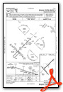
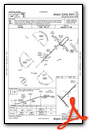
Instrument Approach Procedure (IAP) Charts
Nearby Airports with Instrument Procedures
| ID | Name | Heading / Distance | ||
|---|---|---|---|---|
 |
KOCF | Ocala International-Jim Taylor Field Airport | 130° | 16.9 |
|
X35 | Marion County Airport | 164° | 18.2 |
|
KGNV | Gainesville Regional Airport | 027° | 22.6 |
|
KCGC | Crystal River-Capt Tom Davis Field Airport | 190° | 29.6 |
|
KINF | Inverness Airport | 166° | 33.9 |
|
42J | Keystone Heights Airport | 036° | 36.7 |
|
KCTY | Cross City Airport | 297° | 37.2 |
|
28J | Palatka Municipal - Lt Kay Larkin Field Airport | 065° | 44.8 |
|
KLEE | Leesburg International Airport | 132° | 47.2 |
|
KLCQ | Lake City Gateway Airport | 353° | 49.8 |
|
X23 | Umatilla Municipal Airport | 120° | 50.1 |
|
KBKV | Brooksville-Tampa Bay Regional Airport | 179° | 52.7 |
Airport Images
Do you have a recent image of this airport? Upload it here!


