Login
Register


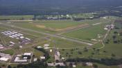
ZPH
Zephyrhills Municipal Airport
Official FAA Data Effective 2024-04-18 0901Z
Chart Supplement

VFR Chart of KZPH
Sectional Charts at SkyVector.com
IFR Chart of KZPH
Enroute Charts at SkyVector.com
Location Information for KZPH
Coordinates: N28°13.60' / W82°9.34'Located 01 miles SE of Zephyrhills, Florida on 813 acres of land. View all Airports in Florida.
Surveyed Elevation is 89 feet MSL.
Operations Data
|
|
Airport Communications
| AWOS-3PT: | 118.975 Tel. 813-780-0031 |
|---|---|
| TAMPA APPROACH: | 119.9 290.3 |
| TAMPA DEPARTURE: | 119.9 290.3 |
| CTAF: | 123.075 |
| UNICOM: | 123.075 |
| AWOS-3 at PCM (13.5 S): | 120.025 813-764-8259 |
| AWOS-3 at VDF (15.8 SW): | 121.125 813-630-0924 |
| ATIS at LAL (16.1 SE): | 118.025 |
Nearby Navigation Aids
|
| ||||||||||||||||||||||||||||||||||||||||||


Runway 01/19
| Dimensions: | 6201 x 100 feet / 1890 x 30 meters | |
|---|---|---|
| Surface: | Asphalt in Fair Condition | |
| Weight Limits: | 16 /F/B/X/T, S-47, D-69 | |
| Edge Lighting: | High Intensity | |
| Runway 01 | Runway 19 | |
| Coordinates: | N28°12.97' / W82°9.20' | N28°13.99' / W82°9.20' |
| Elevation: | 78.7 | 89.3 |
| Traffic Pattern: | Right | |
| Runway Heading: | 0 | 180° True |
| Markings: | Non-Precision Instrument in fair condition. | Non-Precision Instrument in fair condition. |
| Glide Slope Indicator | P4L (3.00° Glide Path Angle) | P4L (3.00° Glide Path Angle) |
| REIL: | Yes | Yes |
| Obstacles: | 49 ft Trees 2385 ft from runway, 225 ft left of center | 75 ft Trees 3365 ft from runway |
Runway 05/23
| Dimensions: | 5001 x 100 feet / 1524 x 30 meters | |
|---|---|---|
| Surface: | Asphalt / Grooved in Good Condition | |
| Weight Limits: | 16 /F/A/X/T, S-53, D-75 | |
| Edge Lighting: | Medium Intensity | |
| Runway 05 | Runway 23 | |
| Coordinates: | N28°13.45' / W82°9.83' | N28°14.06' / W82°9.19' |
| Elevation: | 85.4 | 87.9 |
| Traffic Pattern: | Right | |
| Runway Heading: | 43° True | 223° True |
| Markings: | Non-Precision Instrument in fair condition. | Non-Precision Instrument in fair condition. |
| Glide Slope Indicator | P4L (3.63° Glide Path Angle) | P4L (3.61° Glide Path Angle) |
| Obstacles: | 59 ft Trees 2230 ft from runway, 235 ft right of center | 42 ft Trees 1470 ft from runway, 155 ft right of center |
Services Available
| Fuel: | 100LL (blue), Jet-A, Jet A+ |
|---|---|
| Transient Storage: | Hangars,Tiedowns |
| Airframe Repair: | MAJOR |
| Engine Repair: | MAJOR |
| Bottled Oxygen: | NONE |
| Bulk Oxygen: | NONE |
| Other Services: | GLIDER SERVICE,PILOT INSTRUCTION,PARACHUTE JUMP ACTIVITY,AIRCRAFT RENTAL,GLIDER TOWING SERVICES |
Ownership Information
| Ownership: | Publicly owned | |
|---|---|---|
| Owner: | CITY OF ZEPHYRHILLS | |
| 39450 SOUTH AVENUE | ||
| ZEPHYRHILLS, FL 33542 | ||
| 813-780-0030 | ||
| Manager: | NATHAN COLEMAN | |
| ZEPHYRHILLS MUNICIPAL AIRPORT, 39450 SOUTH AVENUE | ||
| ZEPHYRHILLS, FL 33542 | ||
| 813-780-0030 | ||
Operational Statistics
| Single Engine Aircraft Based on Field: | 93 | Statistics collected for 12 month period ending 2017-12-12 | |
|---|---|---|---|
| Multi-Engine Aircraft Based on Field: | 8 | Annual Commercial Operations: | none |
| Jet Aircraft Based on Field: | none | Annual Commuter Operations: | none |
| Helicopters Based on Field: | 7 | Annual Air Taxi Operations: | 150 |
| Military Aircraft Based on Field: | none | Annual Military Operations: | none |
| Gliders Based on Field: | none | Annual GA Local Operations: | 32850 |
| Ultralights Based on Field: | 1 | Annual GA Itinerant Operations: | 16425 |
Other Remarks
- 24 FT PLINE CROSSES APCH 800-1300 FT FROM RWY 23 END; MKD WITH RED FLAGS.
- PATTERN ALTITUDE TWIN ENGINE 1500 FT AGL.
- GLIDER OPS 6000 FT & BLW SR-SS.
- SKY-DIVING ACFT DESCENDING FROM 13500 FT & ENTERING OPPOSITE TFC PAT FOR RWY 1/19 E OF ARPT.
- PAEW ADJ TO RWYS & TWYS.
- EXERCISE CAUTION; EXTENSIVE ACFT OPS ALL CATS & TYPES USING RWY 1/19; PARL TWY NOT AVBL.
- NOISE SENSITIVE AREA NE & WEST OF ARPT; MNTN PAT ALTS & AVOID PWR CHG OVR RESIDENTAL AREAS.
- FOR CD CTC TAMPA APCH AT 813-878-2528.
- 0LL FUEL AVBL H24 WITH CREDIT CARD; AFT HR FUEL SVC - 813-714-6797.
- ACTVT PAPI RWY 01, 05, 19 & 23; REIL RWY 1 & 19 - CTAF. HIRL RWY 1/19; MIRL RWY 5/23 PRESET TO LOW INTST DUSK-2200; INCR INTST & ACTVT AFT 2200 - CTAF.
Weather Minimums


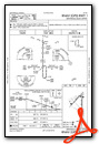
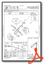
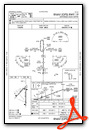
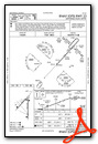
Instrument Approach Procedure (IAP) Charts
Nearby Airports with Instrument Procedures
| ID | Name | Heading / Distance | ||
|---|---|---|---|---|
 |
KPCM | Plant City Airport | 181° | 13.6 |
|
KLAL | Lakeland Linder International Airport | 153° | 16.0 |
|
KVDF | Tampa Exec Airport | 218° | 16.2 |
|
KBKV | Brooksville-Tampa Bay Regional Airport | 313° | 21.7 |
|
KGIF | Winter Haven Regional Airport | 114° | 23.5 |
|
KTPF | Peter O Knight Airport | 220° | 24.3 |
|
KTPA | Tampa International Airport | 233° | 25.0 |
|
KBOW | Bartow Exec Airport | 130° | 26.0 |
|
KMCF | Macdill AFB Airport | 220° | 29.8 |
|
KPIE | St Pete-Clearwater International Airport | 236° | 34.0 |
|
X07 | Lake Wales Municipal Airport | 125° | 34.7 |
|
KCLW | Clearwater Air Park Airport | 245° | 35.3 |


Comments
Nice little airport which
Nice little airport which usually has the best self-serve avgas prices in the Tampa area. However, I would avoid TKM Aviation for any repairs or maintenance.
fly on, support an airport that supports all aviation
after implementing new hangar rules, and fuel surcharge for anyone that bought gas off site( rotax does not recomment 100ll), and then amending to not allow clubs, and being told that the airport is not a "park" fly and go home.. many renters left. if you had a Autogyro or LSA , some harasement even took place , drive bys when you had your hangar was open to see" what you had" or any fuel gugs( looking for surcharges). The CHEAP fuel is not worthit. fly on , go have breakfast. FBo is tiny, if open. The airport is not abiout aviation.. they did not welcom all.. PLEASE AVOID , especially for SUN N FUN... whenthe cramp your planes all over the place.
OH.. yes, Skydiving planes do as they wish, so do the Sailplanes.. carefull on approach.
Often busy but predictable.
Big skydiving operation but they will always use 01-19 in any weather and will avoid disturbing general traffic. Do not overfly the field though. Bad idea. Lots of local pattern training in small aircraft but they also will allow you to get in and out if you announce your needs. If wind is bad enough you can use whatever runway you need, but 05-23 is the common use for all general aviation. 05 is the low wind runway.
Martin R Hulme
Pages