Login
Register


HRF
Ravalli County Airport
Official FAA Data Effective 2024-04-18 0901Z
Chart Supplement

VFR Chart of KHRF
Sectional Charts at SkyVector.com
IFR Chart of KHRF
Enroute Charts at SkyVector.com
Location Information for KHRF
Coordinates: N46°15.43' / W114°7.43'Located 01 miles E of Hamilton, Montana on 439 acres of land. View all Airports in Montana.
Surveyed Elevation is 3635 feet MSL.
Operations Data
|
|
Airport Communications
| AWOS-3P: | 119.825 Tel. 406-375-9149 |
|---|---|
| CTAF: | 122.800 |
| UNICOM: | 122.800 |
| AWOS-AV at 32S (16.6 N): | 120.925 406-777-9884 |
| ASOS at MSO (39.6 N): | 406-728-3743 |
| ATIS at MSO (39.6 N): | 126.65 |
- APCH/P DEP/P SVC PRVDD BY SALT LAKE ARTCC (ZLC) ON FREQS 132.4/338.3 (BUTTE RCAG).
Nearby Navigation Aids
|
| ||||||||||||||||||||||||||||||

Runway 17/35
| Dimensions: | 5200 x 75 feet / 1585 x 23 meters | |
|---|---|---|
| Surface: | Asphalt in Excellent Condition | |
| Weight Limits: | 15 /F/D/Y/U, S-40, D-53 | |
| Edge Lighting: | Medium Intensity | |
| Runway 17 | Runway 35 | |
| Coordinates: | N46°15.86' / W114°7.42' | N46°15.00' / W114°7.44' |
| Elevation: | 3635.6 | 3632.4 |
| Runway Heading: | 181° True | 1° True |
| Markings: | Non-Precision Instrument in good condition. | Non-Precision Instrument in good condition. |
| Glide Slope Indicator | P2L (3.00° Glide Path Angle) | P2L (3.00° Glide Path Angle) |
Services Available
| Fuel: | 100LL (blue), Jet-A, Jet A+ |
|---|---|
| Transient Storage: | Hangars,Tiedowns |
| Airframe Repair: | MAJOR |
| Engine Repair: | MAJOR |
| Bottled Oxygen: | NOT AVAILABLE |
| Bulk Oxygen: | NOT AVAILABLE |
| Other Services: | AIR AMBULANCE SERVICES,CHARTER SERVICE,PILOT INSTRUCTION,PARACHUTE JUMP ACTIVITY,AIRCRAFT RENTAL,AIRCRAFT SALES |
Ownership Information
| Ownership: | Publicly owned | |
|---|---|---|
| Owner: | RAVALLI CO | |
| 215 S. 4TH STREET , SUITE A | ||
| HAMILTON, MT 59840 | ||
| 406-375-6500 | ||
| Manager: | TOM BURGE | |
| 215 S. 4TH STREET, SUITE A | ||
| HAMILTON, MT 59840 | ||
| 406-375-9149 | ||
Operational Statistics
| Single Engine Aircraft Based on Field: | 76 | Statistics collected for 12 month period ending 2019-06-26 | |
|---|---|---|---|
| Multi-Engine Aircraft Based on Field: | 9 | Annual Commercial Operations: | none |
| Jet Aircraft Based on Field: | 2 | Annual Commuter Operations: | none |
| Helicopters Based on Field: | 7 | Annual Air Taxi Operations: | 1900 |
| Military Aircraft Based on Field: | none | Annual Military Operations: | none |
| Gliders Based on Field: | 2 | Annual GA Local Operations: | 13500 |
| Ultralights Based on Field: | none ULTRALIGHT ACTIVITY ON & INVOF ARPT. |
Annual GA Itinerant Operations: | 8200 |
Other Remarks
- FOR CD CTC SALT LAKE ARTCC AT 801-320-2568.
- RWY 17/35 IS LTD BY THE ARPT OPR TO ACFT MAX GWT TKOF 40000 LBS SW AND 53000 LBS DW WO PPR.
- ACTVT PAPI RWY 17, 35; MIRL RWY 17/35 - CTAF. FOR MIRL RWY 17/35 DRG DALGT HRS CTC AP MGR 406-375-9149.
Weather Minimums
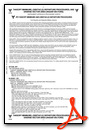
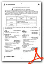
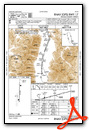
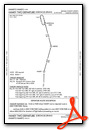
Instrument Approach Procedure (IAP) Charts
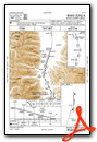
Departure Procedure Obstacles (DPO) Charts
Nearby Airports with Instrument Procedures
| ID | Name | Heading / Distance | ||
|---|---|---|---|---|
 |
32S | Stevensville Airport | 010° | 16.4 |
|
KMSO | Missoula Montana Airport | 001° | 39.6 |
|
3U3 | Bowman Field Airport | 096° | 52.7 |
|
38S | Deer Lodge-City-County Airport | 081° | 57.0 |
|
KSMN | Lemhi County Airport | 171° | 68.8 |
|
KBTM | Bert Mooney Airport | 104° | 70.3 |
|
7S0 | Ronan Airport | 000° | 78.6 |
|
KGIC | Idaho County Airport | 257° | 85.6 |
|
8S1 | Polson Airport | 358° | 86.4 |
|
KRVF | Ruby Valley Field Airport | 118° | 87.8 |
|
KDLN | Dillon Airport | 131° | 89.3 |
|
KHLN | Helena Regional Airport | 075° | 91.3 |
Airport Images

By: tubbs41


Comments
6S5 runway headings and elevations