Login
Register


9K8
Kingman/Clyde Cessna Field Airport
Official FAA Data Effective 2025-11-27 0901Z
Chart Supplement

VFR Chart of 9K8
Sectional Charts at SkyVector.com
IFR Chart of 9K8
Enroute Charts at SkyVector.com
Location Information for 9K8
Coordinates: N37°40.14' / W98°7.43'Located 01 miles NW of Kingman, Kansas on 318 acres of land. View all Airports in Kansas.
Surveyed Elevation is 1606 feet MSL.
Operations Data
|
|
Airport Communications
| AWOS-3PT: | 119.325 Tel. 620-532-1272 |
|---|---|
| WICHITA APPROACH: | 125.5 306.2 |
| WICHITA DEPARTURE: | 125.5 306.2 |
| CTAF: | 122.800 |
| UNICOM: | 122.800 |
| ASOS at HUT (26.9 NE): | 620-662-1071 |
| ATIS at HUT (26.9 NE): | 124.25 |
| AWOS-3PT at PTT (29.7 W): | 118.725 620-672-2793 |
Nearby Navigation Aids
|
| ||||||||||||||||||||||||||||||||||||||||||||||||||||||||||||


Runway 18/36
| Dimensions: | 4300 x 75 feet / 1311 x 23 meters | |
|---|---|---|
| Surface: | Concrete in Fair Condition | |
| Weight Limits: | 11 /R/C/X/U, S-30, D-30 | |
| Edge Lighting: | Medium Intensity | |
| Runway 18 | Runway 36 | |
| Coordinates: | N37°40.44' / W98°7.28' | N37°39.73' / W98°7.41' |
| Elevation: | 1598.7 | 1596.5 |
| Traffic Pattern: | Right | Left |
| Runway Heading: | 188° True | 8° True |
| Declared Distances: | TORA:4300 TODA:4300 ASDA:4300 LDA:4300 | TORA:4300 TODA:4300 ASDA:4300 LDA:4300 |
| Markings: | Non-Precision Instrument in good condition. | Non-Precision Instrument in good condition. |
| Glide Slope Indicator | P2L (3.00° Glide Path Angle) | P2L (3.00° Glide Path Angle) |
| REIL: | Yes | Yes |
| Obstacles: | 15 ft Road 550 ft from runway | 45 ft Trees 1290 ft from runway |
Runway 11/29
| Dimensions: | 3400 x 60 feet / 1036 x 18 meters | |
|---|---|---|
| Surface: | Concrete in Good Condition | |
| Weight Limits: | 11 /R/C/X/U, S-30, D-30 | |
| Runway 11 | Runway 29 | |
| Coordinates: | N37°40.34' / W98°7.86' | N37°40.09' / W98°7.23' |
| Elevation: | 1606.6 | 1592.5 |
| Traffic Pattern: | Right | |
| Runway Heading: | 116° True | 296° True |
| Declared Distances: | TORA:3400 TODA:3400 ASDA:3400 LDA:3400 | TORA:3400 TODA:3400 ASDA:3400 LDA:3400 |
| Markings: | Basic in good condition. | Basic in good condition. |
| Obstacles: | 37 ft Trees 1362 ft from runway, 365 ft right of center | POWER LINE MARKED WITH ORANGE BALLS. |
Services Available
| Fuel: | 100LL (blue) |
|---|---|
| Transient Storage: | Hangars,Tiedowns |
| Airframe Repair: | MAJOR |
| Engine Repair: | MAJOR |
| Bottled Oxygen: | NONE |
| Bulk Oxygen: | NONE |
| Other Services: | CROP DUSTING SERVICES,PILOT INSTRUCTION,AIRCRAFT RENTAL |
Ownership Information
| Ownership: | Publicly owned | |
|---|---|---|
| Owner: | CITY OF KINGMAN | |
| 324 NORTH MAIN | ||
| KINGMAN, KS 67068 | ||
| 620-532-3111 | ||
| Manager: | TIM GULLION | |
| PO BOX 262 | ||
| KINGMAN, KS 67068 | ||
| 620-532-1279 | ||
Other Remarks
- FOR CD CTC WICHITA APCH AT 316-350-1520.
- 0LL SELF SVC FUEL.
- ACTVT REIL RWY 18 & 36; PAPI RWY 18 & 36; MIRL 18/36 - CTAF.
Weather Minimums


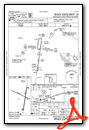
Instrument Approach Procedure (IAP) Charts

Nearby Airports with Instrument Procedures
| ID | Name | Heading / Distance | ||
|---|---|---|---|---|
 |
8K2 | Harper Municipal Airport | 170° | 23.7 |
|
KHUT | Hutchinson Regional Airport | 027° | 26.9 |
|
KPTT | Pratt Regional Airport | 274° | 29.7 |
|
KANY | Anthony Municipal Airport | 176° | 30.6 |
|
KICT | Wichita Dwight D Eisenhower Ntl Airport | 091° | 32.9 |
|
KLYO | Lyons-Rice County Municipal Airport | 352° | 40.5 |
|
KEGT | Wellington Municipal Airport | 120° | 40.7 |
|
KIAB | Mc Connell AFB Airport | 093° | 40.9 |
|
KCEA | Cessna Acft Field Airport | 091° | 41.6 |
|
KAAO | Colonel James Jabara Airport | 083° | 43.2 |
|
KBEC | Beech Factory Airport | 087° | 43.3 |
|
47K | Moundridge Municipal Airport | 042° | 43.8 |
Airport Images
Do you have a recent image of this airport? Upload it here!


