Login
Register


ATK
Atqasuk Edward Burnell Sr Memorial Airport
Official FAA Data Effective 2025-11-27 0901Z
Chart Supplement

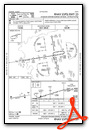
VFR Chart of PATQ
Sectional Charts at SkyVector.com
IFR Chart of PATQ
Enroute Charts at SkyVector.com
Location Information for PATQ
Coordinates: N70°28.03' / W157°26.14'Located 01 miles S of Atqasuk, Alaska. View all Airports in Alaska.
Surveyed Elevation is 101 feet MSL.
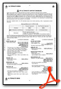
Operations Data
|
|
Airport Communications
| AWOS-3P: | 119.925 Tel. 907-560-7617 |
|---|---|
| CTAF: | 122.900 |
| ASOS at BRW (50.8 N): | 132.150 907-931-6017 |
- APCH/DEP SVC PRVDD BY ANCHORAGE ARTCC ON FREQS 135.3/239.25 (BARROW RCAG).
Nearby Navigation Aids
|
| ||||||||||||||||||

Runway 07/25
| Dimensions: | 4370 x 90 feet / 1332 x 27 meters 90-110 FT BTN LGTS. | |
|---|---|---|
| Surface: | Gravel in Good Condition | |
| Edge Lighting: | Medium Intensity | |
| Runway 07 | Runway 25 | |
| Coordinates: | N70°27.97' / W157°27.20' | N70°28.08' / W157°25.08' |
| Elevation: | 100.8 | 98.9 |
| Traffic Pattern: | Left | Left |
| Runway Heading: | 81° True | 261° True |
| Markings: | None in good condition. | None in good condition. |
| Glide Slope Indicator | P2L (3.00° Glide Path Angle) | P2L (3.00° Glide Path Angle) |
| REIL: | Yes | Yes |
Ownership Information
| Ownership: | Publicly owned | |
|---|---|---|
| Owner: | NORTH SLOPE BOROUGH | |
| BOX 69 | ||
| BARROW, AK 99723 | ||
| 907-852-2611 | ||
| Manager: | GEORGE AHMAOGAK | |
| PO BOX 69 | ||
| BARROW, AK 99723 | ||
| 907-852-0489 | ||
Other Remarks
- ABND RWY VSB N SIDE OF COMMUNITY.
- RWY COND UNMTR; RCMD VISUAL INSP PRIOR TO USE.
- BARROW FSS - 1-800-779-7709.
- 6 IN RUTS 1800 FT FM THR.
- ACTVT REIL RWY 07 & 25; PAPI RWY 07 & 25; MIRL RWY 07/25 - CTAF.
- 24 HR.
Weather Minimums
Instrument Approach Procedure (IAP) Charts

Nearby Airports with Instrument Procedures
| ID | Name | Heading / Distance | ||
|---|---|---|---|---|
 |
PABR | Wiley Post-Will Rogers Memorial Airport | 014° | 51.0 |
|
PAWI | Wainwright Airport | 282° | 52.4 |
Airport Images
Do you have a recent image of this airport? Upload it here!


