



Login
Register
ATU
Casco Cove CGS Airport
Official FAA Data Effective 2026-10-01 0901Z
Chart Supplement

VFR Chart of PAAT
Sectional Charts at SkyVector.com
IFR Chart of PAAT
Enroute Charts at SkyVector.com
Location Information for PAAT
Coordinates: N52°49.95' / E173°10.53'Located 00 miles N of Attu, Alaska. View all Airports in Alaska.
Surveyed Elevation is 88 feet MSL.
Operations Data
|
|
Airport Communications
| CTAF: | 122.900 |
|---|
Nearby Navigation Aids
|
| ||||||||||||||||||

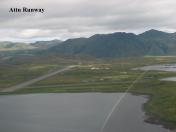
Runway 02/20
| Dimensions: | 5998 x 150 feet / 1828 x 46 meters | |
|---|---|---|
| Surface: | Asphalt in Fair Condition | |
| Weight Limits: | S-32, D-110, ST-150 | |
| Runway 02 | Runway 20 | |
| Coordinates: | N52°49.49' / E173°10.25' | N52°50.41' / E173°10.82' |
| Elevation: | 54.7 | 88.4 |
| Traffic Pattern: | Left | Left |
| Runway Heading: | 21° True | 201° True |
| Markings: | Basic in good condition. | Basic in good condition. |
| REIL: | Yes | |
| Obstacles: | ft Hill 5280 ft from runway | ft Hill 2640 ft from runway |
Ownership Information
| Ownership: | ||
|---|---|---|
| Owner: | US COAST GUARD 17TH DIST | |
| PO BOX 3-5000 | ||
| JUNEAU, AK 99802 | ||
| 907-392-3315 | ||
| Manager: | COMMANDER LORAN STATION | |
| USCG | ||
| ATTU, AK 99619-5000 | ||
| 907-463-2970 | EXT 301. | |
Other Remarks
- PPR FOR USE EXC EMERG.
- 625 FT TWR 1.5 NM NNE OF INTXN OF RWYS.
- SNOW REMOVAL FOR SKED OPS; UNSKED OPS PN.
- 40 MI NW SHEMYA AFS.
- ACTVT REIL RWY 02 - 907-292-3315.
Nearby Airports with Instrument Procedures
| ID | Name | Heading / Distance | ||
|---|---|---|---|---|
 |
PASY | Eareckson As Airport | 101° | 34.9 |
Airport Images
By: Opus

By: Opus



