Login
Register


CDC
Cedar City Regional Airport
Official FAA Data Effective 2026-01-22 0901Z
Chart Supplement

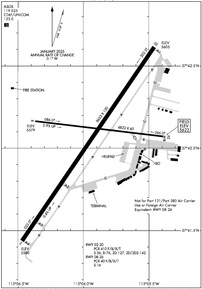
KCDC Airport Diagram
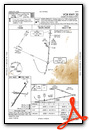
VFR Chart of KCDC
Sectional Charts at SkyVector.com
IFR Chart of KCDC
Enroute Charts at SkyVector.com
Location Information for KCDC
Coordinates: N37°42.06' / W113°5.93'Located 02 miles NW of Cedar City, Utah on 1040 acres of land. View all Airports in Utah.
Surveyed Elevation is 5622 feet MSL.
Operations Data
|
|
Airport Communications
| ASOS: | 119.025 Tel. 435-867-0278 |
|---|---|
| CTAF: | 123.000 |
| UNICOM: | 123.000 |
| AWOS-3 at U55 (34.8 E): | 133.125 435-676-8784 |
| AWOS-3PT at U52 (37.7 NE): | 119.925 435-438-5829 |
| ASOS at MLF (43.8 N): | 135.025 435-387-5201 |
- APCH/DEP CTL SVC PRVDD BY SALT LAKE ARTCC (ZLC) ON 125.575/379.275 (CEDAR CITY RCAG).
Nearby Navigation Aids
|
| ||||||||||||||||||||||||||||||||||||


Runway 02/20
| Dimensions: | 8653 x 150 feet / 2637 x 46 meters | |
|---|---|---|
| Surface: | Asphalt / Grooved in Good Condition | |
| Weight Limits: | S-56, D-76, ST-127, DT-142
PCR VALUE: 410/F/B/X/T
| |
| Edge Lighting: | High Intensity | |
| Runway 02 | Runway 20 | |
| Coordinates: | N37°41.44' / W113°6.47' | N37°42.61' / W113°5.46' |
| Elevation: | 5579.8 | 5605.3 |
| Traffic Pattern: | Left | Right |
| Runway Heading: | 34° True | 214° True |
| Declared Distances: | TORA:8653 TODA:8653 ASDA:8653 LDA:8653 | TORA:8653 TODA:8653 ASDA:8653 LDA:8653 |
| Markings: | Non-Precision Instrument in good condition. | Precision Instrument in good condition. |
| Glide Slope Indicator | P4L (3.00° Glide Path Angle) | P4L (3.00° Glide Path Angle) |
| Approach Lights: | MALSR 1,400 Foot Medium-intensity Approach Lighting System with runway alignment indicator lights. | |
| REIL: | Yes | |
Runway 08/26
RWY 08/26 NOT AVBL FOR PART 121/PART 380 OPS WITH SKED PAX CARRYING OPS MORE THAN 9 PAX SEATS AND NON-SKED PAX CARRYING OPS MORE THAN 30 PAX SEATS. | ||
| Dimensions: | 4822 x 60 feet / 1470 x 18 meters | |
|---|---|---|
| Surface: | Asphalt in Fair Condition | |
| Weight Limits: | S-16
PCR VALUE: 40/F/B/X/T
| |
| Edge Lighting: | Medium Intensity | |
| Runway 08 | Runway 26 | |
| Coordinates: | N37°42.16' / W113°6.37' | N37°42.07' / W113°5.38' |
| Elevation: | 5578.6 | 5622.3 |
| Traffic Pattern: | Left | Right |
| Runway Heading: | 97° True | 277° True |
| Declared Distances: | TORA:4822 TODA:4822 ASDA:4822 LDA:4822 | TORA:4822 TODA:4822 ASDA:4822 LDA:4822 |
| Markings: | Basic in good condition. | Basic in good condition. |
| Glide Slope Indicator | P4L (3.00° Glide Path Angle) | |
| REIL: | Yes | Yes |
| Obstacles: | 40 ft Pole 1800 ft from runway 40 FT POLES ON EXTNDD RWY CNTRLN. |
18 ft Road 661 ft from runway |
Services Available
| Fuel: | 100LL (blue), Jet-A |
|---|---|
| Transient Storage: | Hangars,Tiedowns |
| Airframe Repair: | MAJOR |
| Engine Repair: | MAJOR |
| Bottled Oxygen: | HIGH/LOW |
| Bulk Oxygen: | NOT AVAILABLE |
| Other Services: | AIR FREIGHT SERVICES,CROP DUSTING SERVICES,AIR AMBULANCE SERVICES,CARGO HANDLING SERVICES,CHARTER SERVICE,PILOT INSTRUCTION,AIRCRAFT RENTAL,AIRCRAFT SALES,GLIDER TOWING SERVICES |
Ownership Information
| Ownership: | Publicly owned | |
|---|---|---|
| Owner: | CEDAR CITY CORPORATION | |
| 10 NORTH MAIN | ||
| CEDAR CITY, UT 84720 | ||
| 435-586-2950 | ||
| Manager: | TYLER GALETKA | |
| 2560 AVIATION WAY | ||
| CEDAR CITY, UT 84721 | ||
| 435-867-9408 | ||
Other Remarks
- GA ACFT NOT PERMITTED ON ACR RAMP.
- AUTOROTATE - NO AUTOROTATION TRNG TO HELIPAD. RWY 02/20 CLSD TO HEL RUN-ON LNDG; RWY 08/26 CLSD TO HEL RUN-ON LNDG; TWY A, N OF RWY 8/26 CLSD TO HEL RUN-ON LNDG; TWY C CLSD TO HEL RUN-ON LNDG.
- RWY 02 LEFT TRAFFIC PATTERN EXC HELICOPTERS. RWY 20 RIGHT TRAFFIC EXC HELICOPTERS.
- FOR CD IF UNA TO CTC ON FSS FREQ, CTC SALT LAKE ARTCC AT 801-320-2568.
- TWY B CLSD BTWN TWY C & EAST APRON
- RECOMMNED PILOTS CIRCLE ARPT FOR ALT BEFORE DEPARTING EASTBOUND DUE TO FAST RISING TERRAIN AND HI DENSITY ALT. TURBC LIKELY INVOF MNTS & PASSES.
- TWY B NOT AVBL FOR ACR ACFT.
- DESIGNATED CALM WIND RWY (BLW 5 KTS) IS RWY 20, RGT TFC.
- UNMON SFC CONDS 1900-0700 DLY EXC FOR SKED ACR.
- EXTENSIVE HELICOPTER ACTIVITY.
- EXTENSIVE FLIGHT TRNG INVOF ARPT.
- 0LL 100LL FUEL AVBL 24 HRS SELF-SVC CREDIT CARD SYSTEM.
- ACTVT MALSR RWY 20; REIL RWY 02, 08 & 26; HIRL RWY 02/20; MIRL RWY 08/26 - CTAF. PAPI RWY 02 & 20, 08 OPER CONSLY.
Weather Minimums
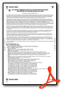

Instrument Approach Procedure (IAP) Charts
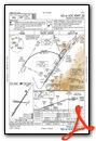

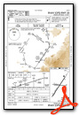
Nearby Airports with Instrument Procedures
| ID | Name | Heading / Distance | ||
|---|---|---|---|---|
 |
U55 | Panguitch Municipal Airport | 075° | 34.7 |
|
U52 | Beaver Municipal Airport | 032° | 37.6 |
|
KMLF | Milford Municipal/Ben and Judy Briscoe Field Airport | 005° | 43.7 |
|
KSGU | St George Regional Airport | 206° | 44.4 |
|
KAZC | Colorado City Municipal Airport | 174° | 44.6 |
|
KBCE | Bryce Canyon Airport | 089° | 45.4 |
|
KKNB | Kanab Municipal Airport | 146° | 49.5 |
|
67L | Mesquite Airport | 221° | 69.3 |
|
1L7 | Escalante Municipal Airport | 087° | 72.8 |
|
KRIF | Richfield Municipal Airport | 036° | 77.8 |
|
KFOM | Fillmore Municipal Airport | 024° | 83.0 |
|
KPGA | Page Municipal Airport | 119° | 91.6 |
Airport Images

By: SV Jenn


