Login
Register


DFFD
Ouagadougou Airport
VFR Chart of DFFD
Sectional Charts at SkyVector.com
IFR Chart of DFFD
Enroute Charts at SkyVector.com
Location Information for DFFD
Coordinates: N12°21.22' / W1°30.72'View all Airports in Kadiogo, Burkina Faso.
Elevation is 1038.0 feet MSL.
Operations Data
|
|
Airport Communications
| OUAGADOUGOU Approach: | 118.10 |
|---|---|
| OUAGADOUGOU Tower: | 118.10 |
Nearby Navigation Aids
|
| ||||||||||||||||||||||||||||||||||||


Runway 04/22
| Dimensions: | 9888 x 148 feet / 3014 x 45 meters | |
|---|---|---|
| Surface: | Hard | |
| Runway 04 | Runway 22 | |
| Coordinates: | N12°20.50' / W1°31.20' | N12°21.87' / W1°30.29' |
| Elevation: | 1034 | 981 |
| Runway Heading: | 035° | 215° |
Nearby Airports with Instrument Procedures
| ID | Name | Heading / Distance | ||
|---|---|---|---|---|
 |
DFOO | Bobo-Dioulasso Airport | 247° | 179.9 |
Airport Images
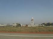
By: Raffles


