Login
Register


BRG
Belen Regional Airport
Official FAA Data Effective 2024-04-18 0901Z
Chart Supplement

VFR Chart of KBRG
Sectional Charts at SkyVector.com
IFR Chart of KBRG
Enroute Charts at SkyVector.com
Location Information for KBRG
Coordinates: N34°38.75' / W106°50.18'Located 03 miles W of Belen, New Mexico on 750 acres of land. View all Airports in New Mexico.
Estimated Elevation is 5199 feet MSL.
Operations Data
|
|
Airport Communications
| AWOS-3PT: | 118.55 Tel. 505-864-4375 |
|---|---|
| ALBUQUERQUE APPROACH: | 123.9 354.1 |
| ALBUQUERQUE DEPARTURE: | 123.9 354.1 |
| UNICOM: | 122.800 |
| CTAF: | 122.800 |
| D-ATIS at ABQ (26.1 NE): | 118.0 |
| ASOS at ABQ (26.2 NE): | 505-242-4044 |
| ATIS at AEG (30.0 N): | 119.025 |
Nearby Navigation Aids
|
| ||||||||||||||||||||||||||||||||||||||||||


Runway 03/21
| Dimensions: | 6601 x 60 feet / 2012 x 18 meters | |
|---|---|---|
| Surface: | Asphalt in Excellent Condition | |
| Weight Limits: | 10 /F/D/X/T, S-12 | |
| Edge Lighting: | Medium Intensity | |
| Runway 03 | Runway 21 | |
| Coordinates: | N34°38.33' / W106°50.49' | N34°39.10' / W106°49.56' |
| Elevation: | 5193.9 | 5174.0 |
| Traffic Pattern: | Left | Right |
| Runway Heading: | 45° True | 225° True |
| Markings: | Non-Precision Instrument in good condition. | Non-Precision Instrument in good condition. |
| Glide Slope Indicator | PSIL (3.00° Glide Path Angle) | |
Runway 13/31
| Dimensions: | 5280 x 75 feet / 1609 x 23 meters | |
|---|---|---|
| Surface: | Asphalt in Good Condition | |
| Weight Limits: | 28 /F/A/X/T | |
| Runway 13 | Runway 31 | |
| Coordinates: | N34°39.11' / W106°50.75' | N34°38.50' / W106°50.01' |
| Elevation: | 5199.5 | 5176.4 |
| Traffic Pattern: | Right | |
| Runway Heading: | 135° True | 315° True |
| Markings: | Basic in good condition. | Basic in good condition. |
Services Available
| Fuel: | 100LL (blue), Jet A-1+ |
|---|---|
| Transient Storage: | Hangars,Tiedowns CALL AHEAD FOR AVAILABILITY: 505-966-2650. |
| Airframe Repair: | MAJOR |
| Engine Repair: | MAJOR |
| Bottled Oxygen: | NOT AVAILABLE |
| Bulk Oxygen: | NOT AVAILABLE |
| Other Services: | PARACHUTE JUMP ACTIVITY,ANNUAL SURVEYING |
Ownership Information
| Ownership: | Publicly owned | |
|---|---|---|
| Owner: | CITY OF BELEN | |
| 100 S. MAIN STREET | ||
| BELEN, NM 87002 | ||
| 505-966-2733 | ||
| Manager: | JOHN THOMPSON | |
| 100 S. MAIN STREET | ||
| BELEN, NM 87002 | ||
| (505) 966-2650 | ||
Operational Statistics
| Single Engine Aircraft Based on Field: | 48 | Statistics collected for 12 month period ending 2021-04-05 | |
|---|---|---|---|
| Multi-Engine Aircraft Based on Field: | 2 | Annual Commercial Operations: | none |
| Jet Aircraft Based on Field: | none | Annual Commuter Operations: | none |
| Helicopters Based on Field: | none | Annual Air Taxi Operations: | 150 |
| Military Aircraft Based on Field: | none | Annual Military Operations: | 7000 |
| Gliders Based on Field: | none | Annual GA Local Operations: | 12000 |
| Ultralights Based on Field: | 2 | Annual GA Itinerant Operations: | 7800 |
Other Remarks
- FREQUENT MIL TRAINING CONDUCTED DAY AND NIGHT. AIRCRAFT RADIO REQUIRED.
- RWY 13/31 CLSD TO ACFT MORE THAN 160,000 LBS.
- FOR CD CTC ALBUQUERQUE ARTCC AT 505-856-4861.
- RWY 13/31, 4 TO 8 INCH DROP-OFF ALONG NORTH EDGE OF PAVEMENT.
- 0LL FOR FULL SERVE JET A FUEL AFT HRS CALL 505-966-2650. 100LL & JET A SELF SERVE 24 HRS WITH MAJOR CREDIT CARD.
- ACTVT PVASI RWY 21; MIRL RWY 03/21 - CTAF.
Weather Minimums
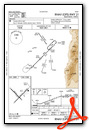
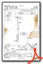
Instrument Approach Procedure (IAP) Charts
Nearby Airports with Instrument Procedures
| ID | Name | Heading / Distance | ||
|---|---|---|---|---|
 |
KABQ | Albuquerque International Sunport Airport | 025° | 26.1 |
|
KAEG | Double Eagle II Airport | 003° | 30.0 |
|
KONM | Socorro Municipal Airport | 185° | 37.5 |
|
0E0 | Moriarty Municipal Airport | 064° | 45.9 |
|
KGNT | Grants-Milan Municipal Airport | 301° | 61.2 |
|
KSAF | Santa Fe Regional Airport | 032° | 68.8 |
|
KLAM | Los Alamos Airport | 020° | 79.0 |
|
KTCS | Truth Or Consequences Municipal Airport | 194° | 87.2 |
|
KSRR | Sierra Blanca Regional Airport | 137° | 96.3 |
|
KLVS | Las Vegas Municipal Airport | 053° | 102.9 |
|
KGUP | Gallup Municipal Airport | 298° | 109.2 |
|
KHMN | Holloman AFB Airport | 161° | 113.4 |
Airport Images
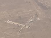
By: Big Orange Bird


