Login
Register


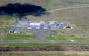
EKVG
Vagar Airport
VFR Chart of EKVG
Sectional Charts at SkyVector.com
IFR Chart of EKVG
Enroute Charts at SkyVector.com
Location Information for EKVG
Coordinates: N62°3.82' / W7°16.63'View all Airports in Vågø, Faroe Islands.
Elevation is 280.0 feet MSL.
Operations Data
|
|
Airport Communications
| VAGAR Emergency: | 121.50 |
|---|---|
| VAGAR Information: | 120.20 |
| VAGAR Information: | 124.85 |
Nearby Navigation Aids
|
| ||||||||||||||||||||||||

Runway 12/30
| Dimensions: | 5902 x 98 feet / 1799 x 30 meters | |
|---|---|---|
| Surface: | Hard | |
| Runway 12 | Runway 30 | |
| Coordinates: | N62°4.02' / W7°17.46' | N62°3.57' / W7°15.63' |
| Elevation: | 264 | 235 |
| Runway Heading: | 125° | 305° |