Login
Register
EPLB
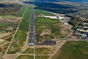
Lublin Airport
VFR Chart of EPLB
Sectional Charts at SkyVector.com
IFR Chart of EPLB
Enroute Charts at SkyVector.com
Location Information for EPLB
Coordinates: N51°14.42' / E22°42.82'View all Airports in Lublin, Poland.
Elevation is 636.0 feet MSL.
Operations Data
|
|
Airport Communications
| LUBLIN TOWER Tower: | 136.43 |
|---|
Nearby Navigation Aids
|
| ||||||||||||||||||||||||||||||||||||
Runway 07/25
| Dimensions: | 8268 x 148 feet / 2520 x 45 meters | |
|---|---|---|
| Surface: | Hard | |
| Runway 07 | Runway 25 | |
| Coordinates: | N51°14.26' / E22°41.76' | N51°14.56' / E22°43.87' |
| Elevation: | 632 | 626 |
| Runway Heading: | 071° | 251° |
Nearby Airports with Instrument Procedures
| ID | Name | Heading / Distance | ||
|---|---|---|---|---|
 |
EPDE | Deblin Airport | 301° | 36.1 |
 |
EPRA | Radom-Sadkow Airport | 279° | 57.2 |
 |
UMBB | Brest Airport | 039° | 68.3 |
 |
EPMM | Minsk Mazowiecki Airport | 325° | 69.7 |
 |
EPRZ | Rzeszow - Jasionka Airport | 201° | 72.9 |
 |
EPWA | Lotnisko Chopina W Warszawie Airport | 311° | 85.7 |
 |
UKLL | Lviv International Airport | 150° | 98.3 |
 |
EPMO | Warszawa/Modlin Airport | 314° | 105.7 |
 |
EPKK | Krakow-Balice Airport | 239° | 131.8 |


