Login
Register


GMMB
Benslimane National Airport
VFR Chart of GMMB
Sectional Charts at SkyVector.com
IFR Chart of GMMB
Enroute Charts at SkyVector.com
Location Information for GMMB
Coordinates: N33°39.27' / W7°13.55'View all Airports in Chaouia - Ouardigha, Morocco.
Elevation is 627.0 feet MSL.
Operations Data
|
|
Airport Communications
| MOHAMMED V APPROACH Approach: | 119.90 |
|---|---|
| MOHAMMED V APPROACH Approach: | 121.30 |
| BENSLIMANE NATIONAL Emergency: | 121.50 |
| BENSLIMANE TOWER Tower: | 118.20 |
Nearby Navigation Aids
|
| ||||||||||||||||||||||||||||||||||||||||||||||||||||||||||||


Runway 14/32
| Dimensions: | 9993 x 148 feet / 3046 x 45 meters | |
|---|---|---|
| Surface: | Hard | |
| Runway 14 | Runway 32 | |
| Coordinates: | N33°39.99' / W7°13.91' | N33°38.81' / W7°12.77' |
| Elevation: | 525 | 617 |
| Runway Heading: | 144° | 324° |
| Displaced Threshold: | 807 Feet | |
Nearby Airports with Instrument Procedures
| ID | Name | Heading / Distance | ||
|---|---|---|---|---|
 |
GMMN | Casablanca/Mohammed V Airport | 225° | 24.9 |
|
GMME | Rabat-Sale Airport | 044° | 33.6 |
|
GMMD | Beni Mellal Airport | 148° | 87.9 |
|
GMFI | Ifrane Airport | 094° | 104.3 |
|
GMFF | Fes Saiss International Airport | 081° | 113.6 |
|
GMTN | Saniat Rmel Airport | 038° | 149.7 |
|
GMFK | Moulay Ali Cherif International Airport | 124° | 175.6 |
Airport Images
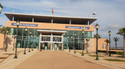
By: makine


