Login
Register
HKNW
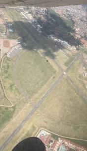
Nairobi Wilson Airport
VFR Chart of HKNW
Sectional Charts at SkyVector.com
IFR Chart of HKNW
Enroute Charts at SkyVector.com
Location Information for HKNW
Coordinates: S1°19.28' / E36°48.90'View all Airports in Nairobi, Kenya.
Elevation is 5546.0 feet MSL.
Operations Data
|
|
Airport Communications
| WILSON GND Ground Control: | 121.90 |
|---|---|
| WILSON TWR Tower: | 118.10 |
Nearby Navigation Aids
|
| ||||||||||||||||||||||||||||||||||||||||||||||||
Runway 14/32
| Dimensions: | 5098 x 75 feet / 1554 x 23 meters | |
|---|---|---|
| Surface: | Hard | |
| Runway 14 | Runway 32 | |
| Coordinates: | S1°19.22' / E36°48.79' | S1°19.74' / E36°49.31' |
| Elevation: | 5511 | 5469 |
| Runway Heading: | 133° | 313° |
| Displaced Threshold: | 636 Feet | |
Runway 07/25
| Dimensions: | 4790 x 79 feet / 1460 x 24 meters | |
|---|---|---|
| Surface: | Unknown | |
| Runway 07 | Runway 25 | |
| Coordinates: | S1°19.50' / E36°48.38' | S1°19.24' / E36°49.12' |
| Elevation: | 5546 | 5478 |
| Runway Heading: | 069° | 249° |
Nearby Airports with Instrument Procedures
| ID | Name | Heading / Distance | ||
|---|---|---|---|---|
 |
HKJK | Nairobi Jomo Kenyatta International Airport | 088° | 6.8 |
 |
HKOK | Olkiombo Airport | 267° | 102.6 |
 |
HKIS | Isiolo Airport | 025° | 109.5 |
 |
HKEL | Eldoret International Airport | 317° | 140.0 |
 |
HKKI | Kisumu Airport | 300° | 145.5 |


