Login
Register


HND
Henderson Exec Airport
Official FAA Data Effective 2024-04-18 0901Z
From the Flight Deck
Chart Supplement

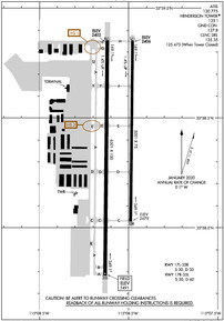
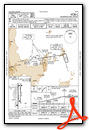
KHND Airport Diagram
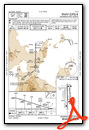
VFR Chart of KHND
Sectional Charts at SkyVector.com
IFR Chart of KHND
Enroute Charts at SkyVector.com
Location Information for KHND
Coordinates: N35°58.37' / W115°8.06'Located 11 miles S of Las Vegas, Nevada on 760 acres of land. View all Airports in Nevada.
Surveyed Elevation is 2491 feet MSL.
Operations Data
|
|
Airport Communications
| ATIS: | 120.775 |
|---|---|
| AWOS-3PT: | 120.775 Tel. 702-614-4537 |
| HENDERSON TOWER: | 125.1 |
| HENDERSON GROUND: | 127.8 |
| LAS VEGAS APPROACH: | 125.475 307.25 |
| LAS VEGAS DEPARTURE: | 125.475 307.25 |
| CLEARANCE DELIVERY: | 135.35 125.475 ;WHEN TWR CLSD |
| UNICOM: | 122.950 |
| NTNDO RNAV STAR: | 125.475 307.25 |
| GAMES STAR: | 125.025 |
| CTAF: | 125.100 |
| ASOS at LAS (6.1 N): | 725-600-7124 |
| D-ATIS at LAS (6.5 N): | 132.4 ;ARR/DEP |
| AWOS-3 at BVU (13.3 E): | 118.475 702-293-1532 |
- ATCT OPER BY MIDWEST ATC INC.
- COMMUNICATIONS PRVDD BY RENO RADIO ON FREQ 122.6 (MOUNT POTOSI RCO).
Nearby Navigation Aids
|
| ||||||||||||||||||||||||||||||||||||


Runway 17R/35L
| Dimensions: | 6501 x 100 feet / 1982 x 30 meters | |
|---|---|---|
| Surface: | Asphalt in Excellent Condition | |
| Weight Limits: | S-30, D-60 | |
| Edge Lighting: | Medium Intensity | |
| Runway 17R | Runway 35L | |
| Coordinates: | N35°58.85' / W115°8.12' | N35°57.78' / W115°8.13' |
| Elevation: | 2401.8 | 2491.4 |
| Runway Heading: | 181° True | 1° True |
| Markings: | Non-Precision Instrument in good condition. | Non-Precision Instrument in good condition. |
| Glide Slope Indicator | P4L (3.00° Glide Path Angle) | P4L (4.30° Glide Path Angle) PAPI UNUSBL BYD 3.3 NM FM RWY THR. |
| REIL: | Yes | Yes |
| Obstacles: | 44 ft Road 1095 ft from runway | |
Runway 17L/35R
OPS DLY 1900-0700. | ||
| Dimensions: | 5001 x 75 feet / 1524 x 23 meters | |
|---|---|---|
| Surface: | Asphalt in Excellent Condition | |
| Weight Limits: | S-30, D-30 | |
| Edge Lighting: | Medium Intensity | |
| Runway 17L | Runway 35R | |
| Coordinates: | N35°58.85' / W115°7.98' | N35°58.03' / W115°7.99' |
| Elevation: | 2405.9 | 2474.9 |
| Runway Heading: | 181° True | 1° True |
| Markings: | Non-Precision Instrument in good condition. | Non-Precision Instrument in good condition. |
| Glide Slope Indicator | P4L (3.00° Glide Path Angle) | P4L (4.30° Glide Path Angle) PAPI UNUSBL BYD 3.5 NM FM RWY THR. |
| REIL: | Yes | Yes |
Services Available
| Fuel: | 100LL (blue), Jet-A |
|---|---|
| Transient Storage: | Tiedowns |
| Airframe Repair: | MINOR |
| Engine Repair: | MINOR |
| Bottled Oxygen: | NOT AVAILABLE |
| Bulk Oxygen: | HIGH/LOW |
| Other Services: | AIR AMBULANCE SERVICES,AVIONICS,CHARTER SERVICE,PILOT INSTRUCTION,AIRCRAFT RENTAL,AIRCRAFT SALES |
Ownership Information
| Ownership: | Publicly owned | |
|---|---|---|
| Owner: | CLARK COUNTY | |
| 3500 EXECUTIVE TERMINAL DR., SUITE 100 | ||
| HENDERSON, NV 89052 | ||
| 702-261-4800 | ||
| Manager: | BRUCE DAUGHERTY | OPS: 702-261-4851. |
| 3500 EXECUTIVE TERMINAL DRIVE, SUITE 100 | ||
| HENDERSON, NV 89052 | ||
| 702-261-4802 | ||
Operational Statistics
| Single Engine Aircraft Based on Field: | 213 | Statistics collected for 12 month period ending 2022-05-31 | |
|---|---|---|---|
| Multi-Engine Aircraft Based on Field: | 17 | Annual Commercial Operations: | none |
| Jet Aircraft Based on Field: | 37 | Annual Commuter Operations: | none |
| Helicopters Based on Field: | 3 | Annual Air Taxi Operations: | 16400 |
| Military Aircraft Based on Field: | none | Annual Military Operations: | 200 |
| Gliders Based on Field: | none | Annual GA Local Operations: | 21800 |
| Ultralights Based on Field: | none | Annual GA Itinerant Operations: | 39600 |
Other Remarks
- COML AIR TOUR TFC ARR FM SE DALGT HR.
- CTN: ACFT DEP RWY 17R OR 35L MUST VFY PSN ON RWY NOT ON PARL TWY.
- FOR CD WHEN ATCT CLSD CTC LAS APCH ON 125.475 OR PH 725-200-4432.
- WHEN SPL EVENT PRKG PPR PROGRAM NOTAM IS ACTV, TSNT ACFT OPERS NOT PERM BASED NEED TO OBTAIN A PPR NR FM AN FBO FOR EA LDG. PPR APPVL & CONFIRMATION NRS CAN BE OBTAINED FM THE SEL FBO AT 702-261-7775. PPR CONFIRMATION NRS SHOULD BE ENTERED IN THE RMKS SECTION OF EACH FLT PLAN.
- 0LL 100LL SELF-SVC H24.
- ACTVT REIL RWY 17R & 35L, 17L & 35R; PAPI RWY 17R & 35L, 17L & 35R; MIRL RWY 17R/35L, 17L/35R - CTAF.
Weather Minimums
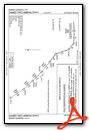
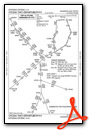
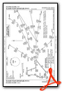
Standard Terminal Arrival (STAR) Charts
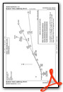
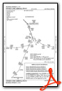
Instrument Approach Procedure (IAP) Charts
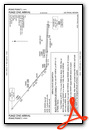
Departure Procedure (DP) Charts
Nearby Airports with Instrument Procedures
| ID | Name | Heading / Distance | ||
|---|---|---|---|---|
 |
KLAS | Harry Reid International Airport | 352° | 6.5 |
|
KBVU | Boulder City Municipal Airport | 096° | 13.4 |
|
KVGT | North Las Vegas Airport | 348° | 14.5 |
|
KLSV | Nellis AFB Airport | 017° | 16.5 |
|
KIFP | Laughlin/Bullhead International Airport | 149° | 56.5 |
|
KIGM | Kingman Airport | 125° | 72.5 |
|
67L | Mesquite Airport | 045° | 73.4 |
|
KEED | Needles Airport | 160° | 76.5 |
|
KHII | Lake Havasu City Airport | 155° | 92.2 |
|
KSGU | St George Regional Airport | 050° | 101.2 |
|
KDAG | Barstow-Daggett Airport | 230° | 105.2 |
|
P20 | Avi Suquilla Airport | 158° | 117.2 |
Airport Images
Do you have a recent image of this airport? Upload it here!


