Login
Register


IA23
Gaa Private Airport
Official FAA Data Effective 2026-01-22 0901Z
VFR Chart of IA23
Sectional Charts at SkyVector.com
IFR Chart of IA23
Enroute Charts at SkyVector.com
Location Information for IA23
Coordinates: N42°48.53' / W91°5.89'Located 02 miles N of Guttenberg, Iowa on 10 acres of land. View all Airports in Iowa.
Estimated Elevation is 620 feet MSL.
Operations Data
|
|
Airport Communications
| AWOS-3 at PDC (12.7 N): | 119.925 608-326-9122 |
|---|---|
| ASOS at OVS (27.9 NE): | 126.775 608-375-2712 |
| AWOS-3 at PVB (29.7 E): | 120.575 608-348-3637 |
Nearby Navigation Aids
|
| ||||||||||||||||||||||||||||||||||||


Runway 17/35
| Dimensions: | 2540 x 160 feet / 774 x 49 meters | |
|---|---|---|
| Surface: | Turf in Good Condition | |
| Runway 17 | Runway 35 | |
Services Available
| Fuel: | NONE |
|---|---|
| Transient Storage: | NONE |
| Airframe Repair: | NONE |
| Engine Repair: | NONE |
| Bottled Oxygen: | NONE |
| Bulk Oxygen: | NONE |
Ownership Information
| Ownership: | Privately Owned | |
|---|---|---|
| Owner: | ABEL ISLAND ASSOCIATION | |
| 130 ABEL DRIVE | ||
| GUTTENBERG, IA 52052 | ||
| 319-480-0913 | ||
| Manager: | GARY FISHER | |
| 130 ABEL DRIVE | ||
| GUTTENBERG, IA 52052 | ||
| 319-480-0913 | ||
Other Remarks
- FREQUENCY:122.9
- FOR CD CTC CHICAGO ARTCC AT 630-906-8921.
Nearby Airports with Instrument Procedures
| ID | Name | Heading / Distance | ||
|---|---|---|---|---|
 |
KPDC | Prairie Du Chien Municipal Airport | 354° | 12.7 |
|
KOVS | Boscobel Airport | 041° | 28.2 |
|
KPVB | Platteville Municipal Airport | 103° | 29.8 |
|
KDBQ | Dubuque Regional Airport | 144° | 29.9 |
|
3Y2 | George L Scott Municipal Airport | 289° | 32.3 |
|
KMXO | Monticello Regional Airport | 184° | 35.4 |
|
KMRJ | Iowa County Airport | 082° | 38.3 |
|
KOLZ | Oelwein Municipal Airport | 259° | 39.5 |
|
KDEH | Decorah Municipal Airport | 314° | 39.7 |
|
KIIB | James H Connell Field At Independence Municipal Airport | 240° | 43.1 |
|
93C | Richland Airport | 050° | 45.3 |
|
KLNR | Tri-County Regional Airport | 058° | 47.1 |
Airport Images
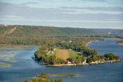
By: Big Orange Bird


