Login
Register


IPL
Imperial County Airport
Official FAA Data Effective 2026-02-19 0901Z
Chart Supplement

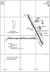
KIPL Airport Diagram
VFR Chart of KIPL
Sectional Charts at SkyVector.com
IFR Chart of KIPL
Enroute Charts at SkyVector.com
Location Information for KIPL
Coordinates: N32°50.05' / W115°34.72'Located 01 miles S of Imperial, California on 370 acres of land. View all Airports in California.
Surveyed Elevation is -53 feet MSL.
Operations Data
|
|
Airport Communications
| ASOS: | 132.175 Tel. 760-355-2851 |
|---|---|
| CTAF: | 122.700 |
| UNICOM: | 122.700 |
| ATIS at NJK (4.6 W): | 269.275 |
| AWOS-1 at 8CN (44.6 W): | 619-478-2213 |
| AWOS-3P at L08 (45.3 NW): | 126.575 760-767-3308 |
- APCH/DEP SVC PRVDD BY YUMA CERAP (ZYL) ON FREQS 132.275/292.2 (EL CENTRO RCAG).
Nearby Navigation Aids
|
| ||||||||||||||||||||||||||||||||||||


Runway 14/32
| Dimensions: | 5308 x 100 feet / 1618 x 30 meters | |
|---|---|---|
| Surface: | Asphalt / Porous Friction Course in Fair Condition | |
| Weight Limits: | S-60, D-80, ST-102, DT-130
PCR VALUE: 183/F/D/W/T
| |
| Edge Lighting: | Medium Intensity | |
| Runway 14 | Runway 32 | |
| Coordinates: | N32°50.55' / W115°34.76' | N32°49.77' / W115°34.28' |
| Elevation: | -55.1 | -53.9 |
| Traffic Pattern: | Left | Right |
| Runway Heading: | 153° True | 333° True |
| Declared Distances: | TORA:5308 TODA:5308 ASDA:5308 LDA:5308 | TORA:5308 TODA:5308 ASDA:5308 LDA:5308 |
| Markings: | Non-Precision Instrument in good condition. | Non-Precision Instrument in good condition. |
| Glide Slope Indicator | P4L (3.00° Glide Path Angle) | P4L (3.00° Glide Path Angle) |
| Obstacles: | 9 ft Fence 425 ft from runway, 130 ft left of center | 15 ft Road 600 ft from runway, 150 ft right of center |
Runway 08/26
RWY 08/26 NOT AVBL FOR PART 121/PART 380 OPS WITH SKED PAX CARRYING OPS MORE THAN 9 PAX SEATS AND NON-SKED PAX CARRYING OPS MORE THAN 30 PAX SEATS. | ||
| Dimensions: | 4501 x 75 feet / 1372 x 23 meters | |
|---|---|---|
| Surface: | Asphalt in Fair Condition | |
| Weight Limits: | S-50, D-50
PCR VALUE: 177/F/D/W/T
| |
| Edge Lighting: | Medium Intensity | |
| Runway 08 | Runway 26 | |
| Coordinates: | N32°49.93' / W115°35.41' | N32°49.93' / W115°34.53' |
| Elevation: | -55.1 | -55.0 |
| Traffic Pattern: | Right | |
| Runway Heading: | 90° True | 270° True |
| Declared Distances: | TORA:4501 TODA:4501 ASDA:4501 LDA:4501 | TORA:4501 TODA:4501 ASDA:4501 LDA:4501 |
| Markings: | Basic in good condition. | Basic in good condition. |
| Glide Slope Indicator | P4L (3.00° Glide Path Angle) | P4L (3.00° Glide Path Angle) |
| Obstacles: | 59 ft Power Line 1600 ft from runway | 32 ft Pole 1575 ft from runway, 250 ft right of center |
Services Available
| Fuel: | 100LL (blue), Jet-A |
|---|---|
| Transient Storage: | Tiedowns |
| Airframe Repair: | NONE |
| Engine Repair: | NONE |
| Bottled Oxygen: | NONE |
| Bulk Oxygen: | NONE |
| Other Services: | AIR FREIGHT SERVICES,CROP DUSTING SERVICES,AIR AMBULANCE SERVICES,CHARTER SERVICE |
Ownership Information
| Ownership: | Publicly owned | |
|---|---|---|
| Owner: | IMPERIAL COUNTY | |
| 1099 AIRPORT ROAD | ||
| IMPERIAL, CA 92251 | ||
| 442-265-1001 | ||
| Manager: | TAIRU ZONG | |
| 155 S. 11TH STREET | ||
| EL CENTRO, CA 92243 | ||
| 442-265-3220 | ||
Other Remarks
- PPR FOR NON-SKEDD AIR CARRIER ARFF SER, CONTACT AMER 442-264-3220.
- TWY C3 CLSD BTN RWY 14/32 AND TWY C5.
- NOISE ABATEMENT: NOISE SENSITIVE AREA NE EDGE OF AP: SCHOOLS AND RESIDENTIAL. CONDS PMTG, HEL ARRS SHOULD BE TO RWY 32, TOUCHDOWN MIDFIELD (BTN TWY A4 AND A3). HEL DEPARTURES SHOULD BE FM RWY 14 MIDFIELD. WHEN CONDS REQ RWY 32 DEPARTURE, MNTN RWY CNTRLN FOR 1.5 NM BEFORE INITIATING TURN. FOR HEL TRNG PATS/AUTOROTATIONS USE RWY 08/26, MAX OF 3 CIRCUITS. BTN SS-SR AVOID CONS PAT CIRCUITS.
- FOR CD CTC YUMA CERAP AT 928-269-9569.
- AVOID NAF EL CENTRO TFC; ACFT DEPG RWY 26 MAKE IMT RIGHT TURN - STAY BELOW 1000 FT; CTC NAF TWR 119.1 FOR ADZY.
- FRQ HIGH-SPD MIL JET TFC TRANSITS IMPERIAL COUNTY TFC AREA WB DESCENDING VFR TO NAF EL CENRTO. AVOID 2500 FT TO 3500 FT MSL NEAR IMPERIAL COUNTY. CTC NAF TWR 119.1 FOR NAVY TFC ADZY.
- RADIO ANT +70 FT LCTD ON CTL TWR AT MIDFIELD RWY 14/32 AND 500 FT WEST RWY CNTRLN.
- ACTVT MIRL RWYS 08/26 & 14/32 - CTAF.
Weather Minimums

Instrument Approach Procedure (IAP) Charts


Nearby Airports with Instrument Procedures
| ID | Name | Heading / Distance | ||
|---|---|---|---|---|
 |
KBWC | Brawley Municipal Airport | 018° | 10.0 |
|
KCLR | Cliff Hatfield Memorial Airport | 009° | 18.0 |
|
L08 | Borrego Valley Airport | 304° | 45.3 |
|
KNYL | Yuma MCAS/Yuma International Airport | 101° | 50.4 |
|
KTRM | Jacqueline Cochran Regional Airport | 328° | 55.7 |
|
KBLH | Blythe Airport | 042° | 64.0 |
|
KUDD | Bermuda Dunes Airport | 327° | 65.0 |
|
KRNM | Ramona Airport | 280° | 68.6 |
|
KSEE | Gillespie Field Airport | 269° | 70.5 |
|
KSDM | Brown Field Municipal Airport | 257° | 72.7 |
|
KPSP | Palm Springs International Airport | 322° | 75.7 |
|
KMYF | Montgomery-Gibbs Exec Airport | 269° | 78.9 |
Airport Images
Do you have a recent image of this airport? Upload it here!


