Login
Register


JNU
Juneau International Airport
Official FAA Data Effective 2025-11-27 0901Z
Chart Supplement

PAJN Airport Diagram

VFR Chart of PAJN
Sectional Charts at SkyVector.com
IFR Chart of PAJN
Enroute Charts at SkyVector.com
Location Information for PAJN
Coordinates: N58°21.28' / W134°34.71'Located 07 miles NW of Juneau, Alaska on 662 acres of land. View all Airports in Alaska.
Estimated Elevation is 25 feet MSL.
Operations Data
|
|
Airport Communications
| ATIS: | 135.2 |
|---|---|
| ASOS: | Tel. 907-789-1243 |
| JUNEAU TOWER: | 118.7 120.7 ;SEASONAL USE ONLY 278.3 |
| JUNEAU GROUND: | 121.9 |
| CLEARANCE DELIVERY: | 121.9 |
| CTAF: | 118.700 |
| NG OPS: | 124.65 64.7 |
| UNICOM: | 122.950 |
| AWOS-3P at HNH (30.5 SW): | 132.05 907-945-3687 |
| AWOS-3P at GST (35.8 W): | 125.9 907-697-2447 |
| AWOS-3P at AGN (51.1 S): | 118.325 907-788-3120 |
- APCH/DEP SVC PRVDD BY ANCHORAGE ARTCC ON FREQ 133.9 (MOUNT ROBERT BARRON RCAG).
- JUNEAU INTL SEAPLANE BASIN CONTACT JUNEAU TWR ON FREQ 118.7 FOR TAXI; TAKE-OFF; AND LANDING INSTRUCTIONS. WATERLANE CONTROLLED BY JUNEAU ATCT. TAXING ACFT SHOULD TAXI CLOCKWISE AROUND THE OUTER EDGE OF FLOAT POND.
- BTN MAY & SEP AN ADDITIONAL LC FREQ OF 120.7 WILL BE IN USE. ITS USE WILL BE ANNOUNCED VIA THE ATIS. ALL OTR TIME USE 118.7 AS LC.
- CTC JUNEAU FSS ON 118.7 FOR ADVISORY SVC WHEN JNU TWR CLSD.
- COMMUNICATIONS PRVDD BY JUNEAU FSS ON FREQ 122.2.
Nearby Navigation Aids
|
| ||||||||||||||||||||||||||||||


Runway 08/26
SAND USED FOR FRICTION MAY NOT MEET FAA SPECS. | ||
| Dimensions: | 8857 x 150 feet / 2700 x 46 meters | |
|---|---|---|
| Surface: | Asphalt / Grooved in Good Condition | |
| Weight Limits: | S-120, D-250, ST-550
PCR VALUE: 892/F/A/X/T
| |
| Edge Lighting: | High Intensity | |
| Runway 08 | Runway 26 | |
| Coordinates: | N58°21.47' / W134°35.82' | N58°21.10' / W134°33.14' |
| Elevation: | 25.0 | 23.4 |
| Traffic Pattern: | Right | Left |
| Runway Heading: | 105° True | 285° True |
| Declared Distances: | TORA:8857 TODA:8857 ASDA:8457 LDA:8457 | TORA:8857 TODA:8857 ASDA:8457 LDA:8457 |
| Markings: | Non-Precision Instrument in fair condition. | Non-Precision Instrument in fair condition. |
| Glide Slope Indicator | V2L (3.50° Glide Path Angle) VASI UNUSBL BYD 06 DEGS LEFT OF CNTRLN. VASI ALIGNED 13 DEG R OF CNTRLN; NOT VIS ON CNTRLN. | P4L (3.50° Glide Path Angle) RWY 26 PAPI UNUSBL BYD 2 NM DUE TO TRRN. |
| RVR Equipment | Touchdown Rollout | Touchdown Rollout |
| Approach Lights: | MALSF 1,400 Foot Medium-intensity Approach Lighting System with sequenced flashers. RLLS LGT: JNUB BATTLESHIP ISLAND, JNUA ENGINEERS CUT, JNU WETLANDS/FLATS. | MALS 1,400 Foot Medium-intensity Approach Lighting System. NSTD; LEN 800 FT. |
| REIL: | Yes | |
| Centerline Lights: | Yes | Yes |
| Obstacles: | 573 ft Tower 7600 ft from runway, 900 ft left of center | |
Runway 08W/26W
| Dimensions: | 4800 x 150 feet / 1463 x 46 meters | |
|---|---|---|
| Surface: | Water | |
| Runway 08W | Runway 26W | |
| Coordinates: | N58°21.38' / W134°35.87' | N58°21.18' / W134°34.42' |
Services Available
| Fuel: | 100LL (blue), Jet A-1+ |
|---|---|
| Transient Storage: | Buoys,Hangars,Tiedowns |
| Airframe Repair: | MAJOR SINGLE/TWIN PROP ENG; TURBIN & AVIONICS. |
| Engine Repair: | MAJOR |
| Bottled Oxygen: | NOT AVAILABLE |
| Bulk Oxygen: | NOT AVAILABLE |
| Other Services: | AIR FREIGHT SERVICES,AIR AMBULANCE SERVICES,AVIONICS,CARGO HANDLING SERVICES,CHARTER SERVICE,PILOT INSTRUCTION |
Ownership Information
| Ownership: | Publicly owned | |
|---|---|---|
| Owner: | CITY OF JUNEAU | |
| 155 S SEWARD | ||
| JUNEAU, AK 99801 | ||
| 907-789-7821 | ||
| Manager: | ANDRES DELGADO | |
| 1873 SHELL SIMMONS DR, SUITE 200 | ||
| JUNEAU, AK 99801 | ||
| 907-789-7821 | ||
Other Remarks
- JUNEAU FSS - LCL 907-789-7380.
- TSNT PUB DOCK SW CORNER.
- SEE SPL NOTICES & GENOT FOR INFO ON OPS IN JUNEAU AREA.
- LENA POINT, PEDERSON HILL & SISTERS IS WX CAMERAS AVBL ON INTERNET AT HTTPS://WEATHERCAMS.FAA.GOV
- COLD TEMPERATURE AIRPORT. ALTITUDE CORRECTION REQUIRED AT OR BELOW 1C.
- APRON TERM RAMP CLSD TO ROTORCRAFT. CUST RAMP APRON CLSD TO WINGSPAN GTR THAN 79 FT. INTL ROTORCRAFT USE E-1 NG RAMP.
- FUEL SVC - UNICOM OR 907-789-0055/5622.
- NG 24 HR PPR - C907-789-3366. WKDAY 0730-1600 CTC NG OPS 10 MIN BFR LNDG - 124.65.
- WILDLIFE & BIRDS ON & INVOF ARPT.
- BATTLESHIP IS RLLS GROUPING; CNTR LGT 582132.88N 1344012.22W. JDL LOC RLLS GROUPING; CNTR LGT 582132.02N 1343810.39W.
- HVY HEL & ACFT ACT APR 15-OCT 1; FULL LEN GASTINEAU CHNL & WI 5 MI.
- PARAGLIDING ACT 3 MI N; INVOF THUNDER MOUNTAIN & OVR GASTINEAU CHNL NEARS DOWNTOWN APR 15-OCT 1; 6000 FT & BLW.
- TPA 1500 AGL FOR LARGE TURBINE ACFT; 1000 FT AGL FOR FIXED WING ACFT; 500 FT AGL FOR HELICOPTERS.
- WHEN ATCT CLSD ACTVT MALSF RWY 08; REIL RWY 26; HIRL RWY 08/26 - CTAF. VASI RWY 08; PAPI RWY 26 OPR CONSLY.
- WHEN ATCT CLSD ARPT ADZY SVC - CTAF.
Weather Minimums
Instrument Approach Procedure (IAP) Charts


Departure Procedure (DP) Charts

Departure Procedure Obstacles (DPO) Charts

Nearby Airports with Instrument Procedures
| ID | Name | Heading / Distance | ||
|---|---|---|---|---|
 |
PAGS | Gustavus Airport | 277° | 35.9 |
|
PASI | Sitka Rocky Gutierrez Airport | 198° | 82.6 |
|
PAFE | Kake Airport | 165° | 86.5 |
|
PAPG | Petersburg James A Johnson Airport | 149° | 107.3 |
|
CYZW | Teslin Airport | 026° | 123.1 |
|
PAWG | Wrangell Airport | 146° | 133.3 |
Airport Images
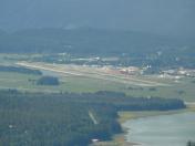
By: busterscv


