Login
Register


AXQ
Clarion County Airport
Official FAA Data Effective 2025-11-27 0901Z
Chart Supplement

VFR Chart of KAXQ
Sectional Charts at SkyVector.com
IFR Chart of KAXQ
Enroute Charts at SkyVector.com
Location Information for KAXQ
Coordinates: N41°13.50' / W79°26.53'Located 03 miles NW of Clarion, Pennsylvania on 219 acres of land. View all Airports in Pennsylvania.
Surveyed Elevation is 1457 feet MSL.
Operations Data
|
|
Airport Communications
| AWOS-3: | 118.275 Tel. 814-297-1486 |
|---|---|
| CTAF: | 122.800 |
| UNICOM: | 122.800 |
| AWOS-3PT at FKL (21.0 NW): | 118.175 (814) 437-2066 |
| ASOS at DUJ (24.7 E): | 119.025 814-328-5140 |
| AWOS-3PT at BTP (35.4 SW): | 121.450 724-586-6434 |
- APCH/DEP SVC PRVDD BY CLEVELAND ARTCC (ZOB) ON FREQS 126.725/291.65 (DUBOIS RCAG).
Nearby Navigation Aids
|
| ||||||||||||||||||||||||||||||||||||||||||||||||||||||||||||


Runway 06/24
| Dimensions: | 5003 x 75 feet / 1525 x 23 meters | |
|---|---|---|
| Surface: | Asphalt in Good Condition | |
| Weight Limits: | S-15 | |
| Edge Lighting: | Medium Intensity | |
| Runway 06 | Runway 24 | |
| Coordinates: | N41°13.20' / W79°26.91' | N41°13.79' / W79°26.15' |
| Elevation: | 1433.1 | 1457.4 |
| Traffic Pattern: | Left | Left |
| Runway Heading: | 45° True | 225° True |
| Markings: | Non-Precision Instrument in good condition. | Non-Precision Instrument in good condition. |
| Glide Slope Indicator | P2L (3.00° Glide Path Angle) | P2L (3.00° Glide Path Angle) |
| REIL: | Yes | Yes |
| Obstacles: | 12 ft Trees 505 ft from runway, 257 ft left of center | 44 ft Trees 851 ft from runway, 329 ft left of center |
Services Available
| Fuel: | 100LL (blue), Jet A+ |
|---|---|
| Transient Storage: | Hangars,Tiedowns |
| Airframe Repair: | NOT AVAILABLE |
| Engine Repair: | NOT AVAILABLE |
| Bottled Oxygen: | NONE |
| Bulk Oxygen: | NONE |
| Other Services: | PILOT INSTRUCTION,AIRCRAFT RENTAL |
Ownership Information
| Ownership: | Publicly owned | |
|---|---|---|
| Owner: | CLARION COUNTY ARPT AUTH | |
| 395 AIRPORT RD | ||
| SHIPPENVILLE, PA 16254 | ||
| 814-226-9993 | ||
| Manager: | WILLIAM GUTH | |
| 395 AIRPORT ROAD | ||
| SHIPPENVILLE, PA 16254 | ||
| (814) 226-9993 | ||
Other Remarks
- THIS AIRPORT HAS BEEN SURVEYED BY THE NATIONAL GEODETIC SURVEY.
- FOR CD CTC CLEVELAND ARTCC AT 440-774-0234/0442.
- 0LL SNGL POINT RFLNG AVBL UPON REQ. JET A WITH PRIST AVBL SELF SVC 24 HRS. 100 LL AVBL SELF SVC 24 HRS.
- ACTVT MIRL RY 06/24, REIL RYS 06 & 24 AND PAPI RYS 06 & 24 - CTAF.
Weather Minimums
Instrument Approach Procedure (IAP) Charts


Nearby Airports with Instrument Procedures
| ID | Name | Heading / Distance | ||
|---|---|---|---|---|
 |
KFKL | Venango Regional Airport | 295° | 21.0 |
|
KDUJ | Dubois Regional Airport | 096° | 24.8 |
|
6G1 | Titusville Airport | 329° | 26.7 |
|
N35 | Punxsutawney Municipal Airport | 123° | 27.9 |
|
6P7 | Mcville Airport | 193° | 30.2 |
|
29D | Grove City Airport | 262° | 33.2 |
|
KBTP | Pittsburgh/Butler Regional Airport | 220° | 35.5 |
|
KIDI | Indiana County/Jimmy Stewart Field Airport | 156° | 38.8 |
|
KPJC | Zelienople Municipal Airport | 232° | 41.3 |
|
8G2 | Corry-Lawrence Airport | 347° | 41.9 |
|
KGKJ | Port Meadville Airport | 304° | 42.4 |
|
KOYM | St Marys Municipal Airport | 074° | 43.9 |
Airport Images
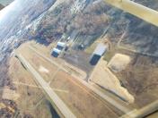
By: manager@clarion...


Comments
Great airport. Will return when able.
Good gas price and very friendly service. Nice facilities to wait out the weather.