Login
Register


GPC
Putnam County Regional Airport
Official FAA Data Effective 2025-11-27 0901Z
Chart Supplement

VFR Chart of KGPC
Sectional Charts at SkyVector.com
IFR Chart of KGPC
Enroute Charts at SkyVector.com
Location Information for KGPC
Coordinates: N39°38.01' / W86°48.83'Located 03 miles SE of Greencastle, Indiana on 192 acres of land. View all Airports in Indiana.
Surveyed Elevation is 842 feet MSL.
Operations Data
|
|
Airport Communications
| AWOS-3PT: | 118.125 Tel. 765-653-1789 |
|---|---|
| INDIANAPOLIS APPROACH: | 119.05 317.8 |
| INDIANAPOLIS DEPARTURE: | 119.05 317.8 |
| UNICOM: | 122.800 |
| CTAF: | 122.800 |
| AWOS-3PT at 2R2 (17.2 NE): | 118.025 317-718-4872 |
| AWOS-3PT at CFJ (21.1 N): | 125.650 765-362-2967 |
| D-ATIS at IND (24.5 E): | 134.25 |
Nearby Navigation Aids
|
| ||||||||||||||||||||||||||||||||||||||||||||||||||||||||||||


Runway 18/36
| Dimensions: | 5002 x 100 feet / 1525 x 30 meters | |
|---|---|---|
| Surface: | Asphalt / Grooved in Excellent Condition | |
| Edge Lighting: | Medium Intensity | |
| Runway 18 | Runway 36 | |
| Coordinates: | N39°38.42' / W86°48.82' | N39°37.60' / W86°48.84' |
| Elevation: | 842.0 | 814.2 |
| Traffic Pattern: | Left | Left |
| Runway Heading: | 181° True | 1° True |
| Markings: | Non-Precision Instrument in good condition. | Non-Precision Instrument in good condition. |
| Glide Slope Indicator | P2L (3.00° Glide Path Angle) | P2L (3.00° Glide Path Angle) |
| REIL: | Yes | |
| Obstacles: | 10 ft Crops 420 ft from runway APCH RATIO 42:1 TO THR. |
13 ft Road 610 ft from runway, 280 ft left of center APCH RATIO 46:1 TO THR. |
Services Available
| Fuel: | 100LL (blue), Jet A-1+ |
|---|---|
| Transient Storage: | Hangars,Tiedowns |
| Airframe Repair: | MAJOR |
| Engine Repair: | MAJOR |
| Bottled Oxygen: | NOT AVAILABLE |
| Bulk Oxygen: | NOT AVAILABLE |
| Other Services: | PILOT INSTRUCTION,AIRCRAFT RENTAL |
Ownership Information
| Ownership: | Publicly owned | |
|---|---|---|
| Owner: | PUTNAM CO AIRPORT AUTHORITY | |
| 1595 BALLARD LANE | ||
| GREENCASTLE, IN 46135 | ||
| 765-653-1763 | ||
| Manager: | P. DOUGLAS MILLER | |
| 1595 BALLARD LANE, PO BOX 318 | ||
| GREENCASTLE, IN 46135 | ||
| 765-721-1289 | ||
Other Remarks
- FOR CD CTC INDIANAPOLIS APCH AT 317-227-5743.
- ACTVT MIRL RWY 18/36 - CTAF; PAPI RWY 18 & 36 OPR CONSLY.
Weather Minimums

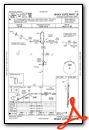
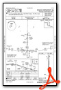
Instrument Approach Procedure (IAP) Charts

Nearby Airports with Instrument Procedures
| ID | Name | Heading / Distance | ||
|---|---|---|---|---|
 |
0I2 | Brazil Clay County Airport | 234° | 16.3 |
|
2R2 | Hendricks County-Gordon Graham Field Airport | 066° | 17.1 |
|
KCFJ | Crawfordsville Regional Airport | 346° | 21.0 |
|
KIND | Indianapolis International Airport | 078° | 24.6 |
|
KHUF | Terre Haute Regional Airport | 244° | 25.4 |
|
3I3 | Sky King Airport | 259° | 26.6 |
|
KEYE | Eagle Creek Airpark Airport | 063° | 26.8 |
|
KBMG | Monroe County Airport | 162° | 30.6 |
 |
8A4 | Indianapolis Downtown Heliport | 075° | 31.8 |
|
KHFY | Indy South Greenwood Airport | 090° | 33.6 |
|
KTYQ | Indianapolis Exec Airport | 047° | 35.2 |
|
KPRG | Edgar County Airport | 275° | 39.9 |
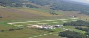
Airport Images

By: 2flaps
By: doug.miller@dix...


