Login
Register


LFMZ
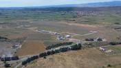
Lezignan Corbieres Airport
VFR Chart of LFMZ
Sectional Charts at SkyVector.com
IFR Chart of LFMZ
Enroute Charts at SkyVector.com
Location Information for LFMZ
Coordinates: N43°10.50' / E2°43.97'View all Airports in Languedoc-Roussillon, France.
Elevation is 204.0 feet MSL.
Operations Data
|
|
Airport Communications
| LEZIGNAN INFORMATION (FR) Information: | 121.20 |
|---|
Nearby Navigation Aids
|
| ||||||||||||||||||||||||||||||||||||||||||||||||||||||||||||


Runway 08/26
| Dimensions: | 3281 x 59 feet / 1000 x 18 meters | |
|---|---|---|
| Surface: | Hard | |
| Runway 08 | Runway 26 | |
| Coordinates: | N43°10.44' / E2°43.60' | N43°10.55' / E2°44.32' |
| Elevation: | 204 | 196 |
| Runway Heading: | 077° | 257° |
Runway 08L/26R
| Dimensions: | 2625 x 262 feet / 800 x 80 meters | |
|---|---|---|
| Surface: | Unknown | |
| Runway 08L | Runway 26R | |
| Coordinates: | N43°10.54' / E2°43.74' | N43°10.62' / E2°44.32' |
| Elevation: | 200 | 194 |
| Runway Heading: | 077° | 257° |
Nearby Airports with Instrument Procedures
| ID | Name | Heading / Distance | ||
|---|---|---|---|---|
 |
LFMK | Carcassonne Salvaza Airport | 277° | 18.8 |
|
LFMP | Perpignan Rivesaltes Airport | 166° | 26.7 |
|
LFMU | Beziers Vias Airport | 071° | 28.6 |
|
LFCK | Castres Mazamet Airport | 319° | 29.9 |
|
LFDJ | Pamiers Airport | 264° | 45.8 |
|
LFCI | Albi Le Sequestre Airport | 328° | 51.8 |
|
LFMT | Montpellier Mediterranee Airport | 065° | 59.1 |
|
LFBF | Toulouse Francazal Airport | 290° | 64.3 |
|
LFBO | Toulouse Blagnac Airport | 295° | 65.8 |
|
LFBR | Muret Lherm Airport | 284° | 66.4 |
|
LFCR | Rodez Aveyron Airport | 351° | 74.7 |
|
LEGE | Girona Airport | 179° | 76.4 |


Comments
Nice small airfield with
Nice small airfield with landing fee of less than 5€
AVGAS price is 2€ TTC on the 18.08.2018
One of the best aircraft painter in Europe is based there : https://www.aerostyll.com/en
I highly recommend him!
Pages