Login
Register


LIPX
Verona/Villafranca Airport
VFR Chart of LIPX
Sectional Charts at SkyVector.com
IFR Chart of LIPX
Enroute Charts at SkyVector.com
Location Information for LIPX
Coordinates: N45°23.78' / E10°53.27'View all Airports in Veneto, Italy.
Elevation is 240.0 feet MSL.
Operations Data
|
|
Airport Communications
| MILANO RADAR Approach: | 124.25 |
|---|---|
| MILANO RADAR Approach: | 135.90 |
| VERONA ARR AND DEP. INFO ATIS: | 124.12 |
| VERONA VILLAFRANCA Emergency: | 121.50 |
| VILLAFRANCA Ground Control: | 121.75 |
| VILLAFRANCA Tower: | 118.65 |
Nearby Navigation Aids
|
| ||||||||||||||||||||||||||||||||||||||||||||||||||||||||||||


Runway 04/22
| Dimensions: | 10066 x 148 feet / 3068 x 45 meters | |
|---|---|---|
| Surface: | Hard | |
| Runway 04 | Runway 22 | |
| Coordinates: | N45°23.26' / E10°52.61' | N45°24.24' / E10°54.04' |
| Elevation: | 220 | 238 |
| Runway Heading: | 043° | 223° |
| Displaced Threshold: | 190 Feet | 1348 Feet |
Nearby Airports with Instrument Procedures
| ID | Name | Heading / Distance | ||
|---|---|---|---|---|
 |
LIPO | Brescia/Montichiari Airport | 274° | 23.6 |
|
LIPL | Ghedi Airport | 274° | 26.3 |
|
LIPT | Vicenza Airport | 068° | 29.0 |
|
LIDT | Trento/Mattarello Airport | 014° | 38.9 |
|
LIMP | Parma Airport | 216° | 42.7 |
|
LIME | Bergamo/Orio Al Serio Airport | 288° | 52.7 |
|
LIPS | Treviso Istrana Airport | 070° | 53.4 |
|
LIPE | Bologna/Borgo Panigale Airport | 161° | 54.8 |
|
LIPH | Treviso/S.Angelo Airport | 074° | 57.3 |
|
LIMS | Piacenza/S.Damiano Airport | 240° | 57.4 |
|
LIPZ | Venezia/Tessera Airport | 083° | 62.2 |
|
LIPV | Venezia/Lido Airport | 087° | 63.4 |
Airport Images
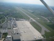
By: Penaz


