Login
Register


LYBE
Beograd/Nikola Tesla Airport
VFR Chart of LYBE
Sectional Charts at SkyVector.com
IFR Chart of LYBE
Enroute Charts at SkyVector.com
Location Information for LYBE
Coordinates: N44°49.17' / E20°18.42'View all Airports in Grad Beograd, Serbia.
Elevation is 336.0 feet MSL.
Operations Data
|
|
Airport Communications
| BEOGRAD RADAR Approach: | 119.10 |
|---|---|
| BEOGRAD RADAR Approach: | 123.97 |
| BEOGRAD RADAR Approach: | 124.42 |
| BEOGRAD RADAR Approach: | 133.10 |
| BEOGRAD INFORMATION ATIS: | 122.92 |
| BEOGRAD Emergency: | 121.50 |
| BEOGRAD GROUND Ground Control: | 118.30 |
| BEOGRAD TOWER Tower: | 118.10 |
| BEOGRAD TOWER Tower: | 118.75 |
Nearby Navigation Aids
|
| ||||||||||||||||||||||||||||||||||||||||||||||||||||||||||||


Runway 12/30
| Dimensions: | 11155 x 148 feet / 3400 x 45 meters | |
|---|---|---|
| Surface: | Hard | |
| Runway 12 | Runway 30 | |
| Coordinates: | N44°49.59' / E20°17.46' | N44°48.73' / E20°19.39' |
| Elevation: | 317 | 333 |
| Runway Heading: | 117° | 297° |
| Displaced Threshold: | 1312 Feet | |
Nearby Airports with Instrument Procedures
| ID | Name | Heading / Distance | ||
|---|---|---|---|---|
 |
LYBT | Pukovnik-Pilot Milenko Pavlovi Airport | 341° | 7.7 |
|
LYVR | Vrsac Airport | 064° | 47.0 |
|
LYUZ | Uzice/Ponikve Airport | 205° | 61.2 |
|
LYKV | Morava Airport | 168° | 61.3 |
|
LQTZ | Tuzla International Airport | 252° | 71.2 |
|
LRTR | Timisoara/Traian Vuia Airport | 035° | 73.7 |
|
LDOS | Osijek Klisa Airport | 301° | 74.4 |
|
LRAR | Arad Airport | 025° | 90.9 |
|
LQSA | Sarajevo International Airport | 235° | 103.9 |
|
LYNI | Nis/Konstantin Veliki Airport | 142° | 111.3 |
|
LHPP | Pecs-Pegany Airport | 309° | 112.0 |
|
LHBC | Bekescsaba Airport | 017° | 117.5 |
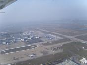
Airport Images

By: Milutin123456
By: Tommaso


Comments
Multiple Inconsistencies
Missing runway 12R/30L
There are two tower frequencies instead of one (possibally the ALTN frequency) but misleading
https://smatsa.rs/upload/aip/published/30-Oct-2025-A/2025-10-30-AIRAC/html/index_commands.html