



Login
Register
MAZ
Eugenio Maria De Hostos Airport
Official FAA Data Effective 2026-10-01 0901Z
Chart Supplement

TJMZ Airport Diagram

VFR Chart of TJMZ
Sectional Charts at SkyVector.com
IFR Chart of TJMZ
Enroute Charts at SkyVector.com
Location Information for TJMZ
Coordinates: N18°15.34' / W67°8.91'Located 03 miles N of Mayaguez, Puerto Rico on 172 acres of land. View all Airports in Puerto Rico.
Surveyed Elevation is 28 feet MSL.
Operations Data
|
|
Airport Communications
| CTAF: | 122.800 |
|---|---|
| UNICOM: | 122.800 |
| AWOS-3PT at BQN (14.1 N): | 118.325 787-997-0715 |
| ATIS at BQN (14.4 N): | 118.325 |
| AWOS-3PT at PSE (36.4 SE): | 118.4 787-843-0444 |
- APCH/DEP SVC PRVDD BY SAN JUAN CERAP ON FREQS 118.75/269.0 (EL YUNQUE RCAG).
- CLNC DEL PRVDD BY SAN JUAN CERAP ON FREQ 121.7.
Nearby Navigation Aids
|
| ||||||||||||||||||||||||||||||||||||||||||||||||||||||


Runway 09/27
| Dimensions: | 4998 x 75 feet / 1523 x 23 meters | |
|---|---|---|
| Surface: | Asphalt in Good Condition | |
| Weight Limits: | S-85, D-108, ST-170 | |
| Edge Lighting: | Medium Intensity | |
| Runway 09 | Runway 27 | |
| Coordinates: | N18°15.24' / W67°9.33' | N18°15.44' / W67°8.49' |
| Elevation: | 16.3 | 24.5 |
| Traffic Pattern: | Left | Left |
| Runway Heading: | 76° True | 256° True |
| Displaced Threshold: | 299 Feet | |
| Declared Distances: | TORA:4998 TODA:4998 ASDA:4998 LDA:4699 | TORA:4998 TODA:4998 ASDA:4699 LDA:4699 |
| Markings: | Non-Precision Instrument in good condition. | Non-Precision Instrument in good condition. |
| Glide Slope Indicator | P4L (3.00° Glide Path Angle) | P4L (3.50° Glide Path Angle) |
| REIL: | Yes REIL OTS INDEFLY. | REIL OTS INDEFLY. |
| Obstacles: | 60 ft Tree 780 ft from runway, 275 ft right of center 47 FT MARKED/LIGHTED POWER LINES, 1800 FT DSTC, 410 FT L/R,, 34:1. OBSTN CLNC SLP 18:1 TO DTHR. |
45 ft Trees 1150 ft from runway, 250 ft right of center 20 FT TREES, 0-199 FT DSTC, 240 R. |
Services Available
| Fuel: | NONE |
|---|---|
| Transient Storage: | NONE |
| Airframe Repair: | NONE |
| Engine Repair: | NONE |
| Bottled Oxygen: | NOT AVAILABLE |
| Bulk Oxygen: | NOT AVAILABLE |
Ownership Information
| Ownership: | Publicly owned | |
|---|---|---|
| Owner: | PUERTO RICO PORTS AUTH | |
| P.O. BOX 362829 | ||
| SAN JUAN, PR 00932-2829 | ||
| 787-729-8715 | ||
| Manager: | WILLIAM FEBLES | ON-SITE OPER MGR OSVALDO TUBENS MANDEZ, 787-832-3390, OTUBENS@PRPA.PR.GOV |
| BOX 710 | ||
| MAYAGUEZ, PR 00681-0710 | ||
| 787-833-0148 | ||
Other Remarks
- BIRDS ON AND INVOF ARPT.
- FOR CD IF FREQ ARE OTS CTC SAN JUAN CERAP AT 787-253-8664/8667
- ULTRALIGHT ACT.
- ACTVT RWY 09/27 MIRLS & PAPI RWY 27 - CTAF. PAPI RWY 9 OPER CONTIUNOUS.
Weather Minimums


Instrument Approach Procedure (IAP) Charts


Nearby Airports with Instrument Procedures
| ID | Name | Heading / Distance | ||
|---|---|---|---|---|
 |
TJBQ | Rafael Hernandez Airport | 004° | 14.3 |
|
TJPS | Mercedita Airport | 113° | 36.5 |
|
TJIG | Fernando Luis Ribas Dominicci Airport | 078° | 61.1 |
|
TJSJ | Luis Munoz Marin International Airport | 080° | 66.3 |
|
TJVQ | Antonio Rivera Rodriguez Airport | 094° | 94.8 |
|
TIST | Cyril E King Airport | 087° | 124.3 |
|
TISX | Henry E Rohlsen Airport | 103° | 138.2 |
|
TUPJ | Terrance B Lettsome International Airport | 085° | 149.2 |
Airport Images
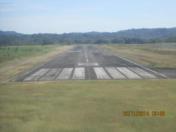
By: yaque33



