Login
Register


MDQ
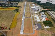
Huntsville Exec Tom Sharp Jr Field Airport
Official FAA Data Effective 2024-03-21 0901Z
Chart Supplement

VFR Chart of KMDQ
Sectional Charts at SkyVector.com
IFR Chart of KMDQ
Enroute Charts at SkyVector.com
Location Information for KMDQ
Coordinates: N34°51.56' / W86°33.45'Located 01 miles NE of Huntsville, Alabama on 485 acres of land. View all Airports in Alabama.
Surveyed Elevation is 763 feet MSL.
Operations Data
|
|
Airport Communications
| AWOS-3PT: | 120.000 Tel. 256-829-1242 |
|---|---|
| HUNTSVILLE APPROACH: | 125.6 354.1 |
| HUNTSVILLE DEPARTURE: | 125.6 354.1 |
| UNICOM: | 123.000 |
| CTAF: | 123.000 |
| AWOS-3 at FYM (12.1 N): | 135.275 931-433-5916 |
| ATIS at HUA (12.5 SW): | 120.65 |
| ATIS at HSV (17.1 SW): | 121.25 |
- APCH/DEP SVC PRVDD BY MEMPHIS ARTCC ON FREQS 120.8/307.0 (HUNTSVILLE RCAG) WHEN HUNTSVILLE APCH CTL CLSD.
Nearby Navigation Aids
|
| ||||||||||||||||||||||||||||||||||||||||||


Runway 18/36
| Dimensions: | 6500 x 100 feet / 1981 x 30 meters | |
|---|---|---|
| Surface: | Asphalt / Grooved in Fair Condition | |
| Weight Limits: | S-60, D-75, ST-140 | |
| Edge Lighting: | Medium Intensity | |
| Runway 18 | Runway 36 | |
| Coordinates: | N34°52.10' / W86°33.44' | N34°51.03' / W86°33.46' |
| Elevation: | 719.0 | 763.2 |
| Traffic Pattern: | Left | Right |
| Runway Heading: | 181° True | 1° True |
| Markings: | Precision Instrument in good condition. | Non-Precision Instrument in good condition. |
| Glide Slope Indicator | P4L (3.00° Glide Path Angle) | P4L (3.00° Glide Path Angle) |
| REIL: | Yes | Yes |
| Obstacles: | 32 ft Trees 1019 ft from runway, 140 ft left of center | |
Services Available
| Fuel: | 100LL (blue), Jet-A |
|---|---|
| Transient Storage: | Hangars,Tiedowns |
| Airframe Repair: | MAJOR |
| Engine Repair: | MAJOR |
| Bottled Oxygen: | NONE |
| Bulk Oxygen: | LOW |
| Other Services: | PILOT INSTRUCTION,AIRCRAFT RENTAL |
Ownership Information
| Ownership: | Publicly owned | |
|---|---|---|
| Owner: | MADISON CO EXEC ARPT AUTH | TOM SHARP. |
| PO BOX 110 | ||
| MERIDIANVILLE, AL 35759 | ||
| 256-828-3883 | ||
| Manager: | RAY MEYER | |
| 360 CLYDE SHELTON DRIVE | ||
| MERIDIANVILLE, AL 35759 | ||
| 256-828-1403 | ||
Operational Statistics
| Single Engine Aircraft Based on Field: | 94 | Statistics collected for 12 month period ending 2017-10-16 | |
|---|---|---|---|
| Multi-Engine Aircraft Based on Field: | 10 | Annual Commercial Operations: | none |
| Jet Aircraft Based on Field: | 2 | Annual Commuter Operations: | none |
| Helicopters Based on Field: | none | Annual Air Taxi Operations: | 1860 |
| Military Aircraft Based on Field: | none | Annual Military Operations: | 600 |
| Gliders Based on Field: | none | Annual GA Local Operations: | 15000 |
| Ultralights Based on Field: | none | Annual GA Itinerant Operations: | 16800 |
Other Remarks
- GCO AVBL ON FREQ 121.725 THRU HUNTSVILLE APCH & ANNISTON FSS.
- FOR CD IF UNA VIA GCO, CTC HUNTSVILLE APCH AT 256-542-2098. WHEN APCH CLSD CTC MEMPHIS ARTCC AT 901-368-8453/8449.
- ACTVT REILS RWY 18 & 36; PAPI RWY 18 & 36; MIRL RWY 18/36 - CTAF.
Weather Minimums
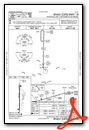
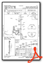
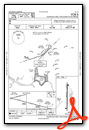
Instrument Approach Procedure (IAP) Charts
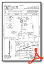
Nearby Airports with Instrument Procedures
| ID | Name | Heading / Distance | ||
|---|---|---|---|---|
 |
KFYM | Fayetteville Municipal Airport | 358° | 12.0 |
|
KHSV | Huntsville International-Carl T Jones Field Airport | 219° | 17.1 |
|
KDCU | Pryor Field Regional Airport | 237° | 22.8 |
|
4A6 | Scottsboro Municipal-Word Field Airport | 110° | 29.1 |
|
KGZS | Abernathy Field Airport | 305° | 30.3 |
|
KBGF | Winchester Municipal Airport | 051° | 30.8 |
|
8A1 | Guntersville Municipal/Joe Starnes Field Airport | 151° | 30.9 |
|
5M0 | Hartselle/Morgan County Regional Airport | 214° | 32.8 |
|
KTHA | Tullahoma Regional/Wm Northern Field Airport | 026° | 34.7 |
|
KCMD | Cullman Regional/Folsom Field Airport | 202° | 38.4 |
|
8A0 | Albertville Regional/Thomas J Brumlik Field Airport | 158° | 40.6 |
|
KLUG | Ellington Airport | 342° | 40.6 |