Login
Register


ORT
Northway Airport
Official FAA Data Effective 2026-02-19 0901Z
Chart Supplement

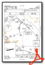
VFR Chart of PAOR
Sectional Charts at SkyVector.com
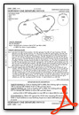
IFR Chart of PAOR
Enroute Charts at SkyVector.com
Location Information for PAOR
Coordinates: N62°57.67' / W141°55.68'Located 00 miles S of Northway, Alaska on 1150 acres of land. View all Airports in Alaska.
Surveyed Elevation is 1720 feet MSL.
Operations Data
|
|
Airport Communications
| ASOS: | 135.4 Tel. 907-778-2282 |
|---|---|
| CTAF: | 123.600 |
| AWOS-3P at 6K8 (35.4 NW): | 118.1 907-269-2706 |
- APCH/DEP SVC PRVDD BY ANCHORAGE ARTCC ON FREQS 126.55/323.0 (NORTHWAY RCAG).
- CONTRACT WX OBS IS AVBL WHEN ORT FSS CLSD ON 133.55 OR PHONE 907-778-2240.
- COMMUNICATIONS PRVDD BY NORTHWAY FSS ON FREQ 123.6 (CTAF).
Nearby Navigation Aids
|
| ||||||||||||||||||

Runway 06/24
FQT VRB STRONG CROSSWIND. | ||
| Dimensions: | 5100 x 100 feet / 1554 x 30 meters | |
|---|---|---|
| Surface: | Asphalt / Grooved in Good Condition | |
| Edge Lighting: | Medium Intensity | |
| Runway 06 | Runway 24 | |
| Coordinates: | N62°57.57' / W141°56.58' | N62°57.77' / W141°54.79' |
| Elevation: | 1720.1 | 1718.7 |
| Traffic Pattern: | Left | Left |
| Runway Heading: | 76° True | 256° True |
| Markings: | Non-Precision Instrument in good condition. | Non-Precision Instrument in good condition. |
| Glide Slope Indicator | P4L (3.00° Glide Path Angle) | P4L (3.00° Glide Path Angle) |
| REIL: | Yes | |
| Obstacles: | 61 ft Trees 2029 ft from runway | 60 ft Trees 1195 ft from runway, 425 ft left of center |
Services Available
| Fuel: | NONE |
|---|---|
| Transient Storage: | Hangars |
| Airframe Repair: | NOT AVAILABLE |
| Engine Repair: | NOT AVAILABLE |
| Bottled Oxygen: | NOT AVAILABLE |
| Bulk Oxygen: | NOT AVAILABLE |
Ownership Information
| Ownership: | Publicly owned | |
|---|---|---|
| Owner: | ALASKA DOT&PF NORTHERN REGION | |
| 2301 PEGER RD. | ||
| FAIRBANKS, AK 99709 | ||
| 907-451-2200 | ||
| Manager: | SAM JENNINGS | |
| BOX 356 | ||
| TOK, AK 99780 | ||
| 907-883-5128 | ||
Other Remarks
- WINTER SN REMOVAL OPS - CTAF.
- NORTHWAY & KNOB RIDGE WX CAMERAS AVBL AT HTTPS://WEATHERCAMS.FAA.GOV/.
- FOREIGN ARR ORT/PAOR OR YARGER LAKE +2 HR PPR; NMLLY 1800Z-0000Z - U.S. CUSTOMS 907-774-2242/2252.
- ELEC FILED EAPIS MANIFEST REQ PRIOR TO DEP.
- COLD TEMPERATURE AIRPORT. ALTITUDE CORRECTION REQUIRED AT OR BELOW -48C.
- FLOATPLANE CUST SVC AVBL YARGER LAKE 8 NM E.
- SUAIS - 125.3/126.3 OR 800-758-8723.
- RWY COND UNMN; RCMD VISUAL INSP PRIOR TO LNDG.
- SKI STRIP PARL & ADJ THR NW SIDE.
- ACTVT REIL RWY 24; PAPI RWY 06 & 24; MIRL RWY 06/24 - CTAF.
- MAY 1-SEP 30; 0815-1745; AFT HR - FAI FSS.
Weather Minimums

Instrument Approach Procedure (IAP) Charts


Departure Procedure Obstacles (DPO) Charts
Nearby Airports with Instrument Procedures
| ID | Name | Heading / Distance | ||
|---|---|---|---|---|
 |
PFTO | Tok Junction Airport | 308° | 35.7 |
|
CYDA | Dawson City Airport | 047° | 99.5 |
|
PAEG | Eagle Airport | 010° | 111.3 |
|
CYDB | Burwash Airport | 138° | 125.5 |
Airport Images
Do you have a recent image of this airport? Upload it here!


