



Login
Register
OYSN
Sanaa International Airport
VFR Chart of OYSN
Sectional Charts at SkyVector.com
IFR Chart of OYSN
Enroute Charts at SkyVector.com
Location Information for OYSN
Coordinates: N15°28.77' / E44°13.18'View all Airports in Amanat Al Asimah, Yemen.
Elevation is 7216.0 feet MSL.
Operations Data
|
|
Airport Communications
| SANA'A Approach: | 125.70 |
|---|---|
| SANNA INTL Ground Control: | 121.60 |
| SANNA INTL Tower: | 118.10 |
| SANNA INTL Tower: | 118.90 |
Nearby Navigation Aids
|
| ||||||||||||||||||||||||||||||||||||||||||||||||||||||


Runway 18/36
| Dimensions: | 10669 x 148 feet / 3252 x 45 meters | |
|---|---|---|
| Surface: | Hard | |
| Runway 18 | Runway 36 | |
| Coordinates: | N15°29.46' / E44°13.18' | N15°27.69' / E44°13.19' |
| Elevation: | 7165 | 7216 |
| Runway Heading: | 177° | 357° |
Nearby Airports with Instrument Procedures
| ID | Name | Heading / Distance | ||
|---|---|---|---|---|
 |
OYHD | Hodeidah Airport | 239° | 84.3 |
|
OEGN | Jazan/King Abdullah Abdulaziz Airport | 312° | 126.9 |
|
OESH | Sharurah Airport | 054° | 205.2 |
Airport Images
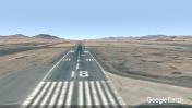
By: Xavier101

By: Xavier101



Comments
only comment for this airport so far...
Xavier101@mail.ru
About This Airport
Xavier101@mail.ru