Login
Register


YAK
Yakutat Airport
Official FAA Data Effective 2025-11-27 0901Z
Chart Supplement

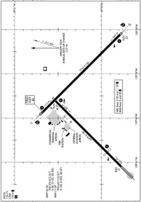
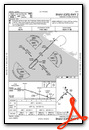
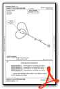
PAYA Airport Diagram
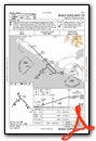
VFR Chart of PAYA
Sectional Charts at SkyVector.com
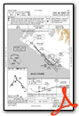
IFR Chart of PAYA
Enroute Charts at SkyVector.com
Location Information for PAYA
Coordinates: N59°30.20' / W139°39.62'Located 03 miles SE of Yakutat, Alaska. View all Airports in Alaska.
Surveyed Elevation is 39 feet MSL.
Operations Data
|
|
Airport Communications
| ASOS: | 135.75 Tel. 907-784-3116 |
|---|---|
| CTAF: | 123.600 |
- APCH/DEP SVC PRVDD BY ANCHORAGE ARTCC ON FREQS 119.0/263.1 (YAKUTAT RCAG).
- COMMUNICATIONS PRVDD BY JUNEAU FSS ON FREQ 123.6 (YAKUTAT RCO).
Nearby Navigation Aids
|
| ||||||||||||||||||||||||


Runway 11/29
| Dimensions: | 7732 x 150 feet / 2357 x 46 meters | |
|---|---|---|
| Surface: | Asphalt / Grooved in Good Condition | |
| Weight Limits: | S-120, D-203, ST-271
PCR VALUE: 632/F/D/X/T
| |
| Edge Lighting: | High Intensity | |
| Runway 11 | Runway 29 | |
| Coordinates: | N59°30.69' / W139°39.88' | N59°29.79' / W139°38.12' |
| Elevation: | 39.7 | 33.1 |
| Traffic Pattern: | Left | Right |
| Runway Heading: | 135° True | 315° True |
| Markings: | Precision Instrument in fair condition. | Precision Instrument in good condition. |
| Glide Slope Indicator | P4L (3.00° Glide Path Angle) | P4L (3.00° Glide Path Angle) |
| RVR Equipment | Touchdown | Rollout |
| Approach Lights: | MALSR 1,400 Foot Medium-intensity Approach Lighting System with runway alignment indicator lights. | MALSR 1,400 Foot Medium-intensity Approach Lighting System with runway alignment indicator lights. |
| Obstacles: | 55 ft Trees 1800 ft from runway | |
Runway 02/20
UNMNTND & UNMNT 1 OCT - 1 MAY. RWY 02/20 NOT AVBL FOR PART 121/380 SKED AND NON-SKED OPS WITH PAX CARRYING OPS MORE THAN 30 PAX SEATS. | ||
| Dimensions: | 6475 x 150 feet / 1974 x 46 meters | |
|---|---|---|
| Surface: | Concrete in Good Condition | |
| Weight Limits: | S-38, D-107, ST-200
PCR VALUE: 574/R/C/X/T
| |
| Edge Lighting: | High Intensity RWY LGTS RAISED 30 IN. | |
| Runway 02 | Runway 20 | |
| Coordinates: | N59°29.78' / W139°41.09' | N59°30.53' / W139°39.61' |
| Elevation: | 21.3 | 36.9 |
| Traffic Pattern: | Right | Left |
| Runway Heading: | 45° True | 225° True |
| Displaced Threshold: | 1388 Feet | |
| Declared Distances: | TORA:6475 TODA:6475 ASDA:6475 LDA:5087 | TORA:5087 TODA:5087 ASDA:6475 LDA:6475 |
| Markings: | Non-Precision Instrument in good condition. | Non-Precision Instrument in good condition. |
| Glide Slope Indicator | P4R (3.00° Glide Path Angle) | P4L (3.00° Glide Path Angle) |
| REIL: | Yes | Yes |
| Obstacles: | 42 ft Brush 1040 ft from runway | 15 ft Brush 500 ft from runway |
Services Available
| Fuel: | 100 (green), Jet A-1+ |
|---|---|
| Transient Storage: | NONE |
| Airframe Repair: | NOT AVAILABLE |
| Engine Repair: | NOT AVAILABLE |
| Bottled Oxygen: | NOT AVAILABLE |
| Bulk Oxygen: | NOT AVAILABLE |
| Other Services: | CARGO HANDLING SERVICES |
Ownership Information
| Ownership: | Publicly owned | |
|---|---|---|
| Owner: | ALASKA DOT&PF SOUTHCOAST REGION | |
| 6860 GLACIER HWY | ||
| JUNEAU, AK 99801-7999 | ||
| 907-465-1779 | ||
| Manager: | ROBERT LEKANOF | |
| BOX 186 | ||
| YAKUTAT, AK 99689 | ||
| 907-784-3293 | ||
Other Remarks
- CTN: SN PILES & BERMS ON RAMP & TWY EDGES 1 OCT - 1 MAY.
- PAJA NA.
- TWY A1, D & APRON B CLSD TO 12500 LB & OVR.
- SAND GRAD LRGR THAN FAA RCMDD/SEE AC150/5200-30.
- TWY B, C, & D UNMNTND, UNMNT & LGT OTS 1 OCT - 1 MAY.
- CARGO OPS OVR 100000 24 HR PPR - 907-784-3476.
- WX CAMERAS AVBL AT: HTTPS://WEATHERCAMS.FAA.GOV.
- PAPI RWY 02, 11, & 29; HIRL RWY 02/20; REIL RWY 02/20 OTS 1 OCT - 1 MAY.
- ARPT & RWY COND RPRT, SN REMOVAL, WILDLIFE & ICE CTL DURG MAINT DUTY HR 0630-1730; AFT HR AMGR.
- WX BLN LAUNCH FAC ON ARPT, SEE INSIDE BACK COVER FOR OPS DETAILS.
- FUEL AVBL H24 WITH CREDIT CARD - 907-784-3311.
- BIRDS & WILDLIFE ON & INVOF RWY.
- TWY C & A1 CLSD DURG ACR OPS & 15 MIN AFT FOR JET BLAST.
- PAEW ON RWY; RCMD VISUAL INSP BFR USE - CTC FSS FOR NOTAM.
- ACTVT MALSR RWY 11 & 29; REIL RWY 02/20; PAPI RWY 11/29 & 02/20; HIRL RWY 02/20, 11/29; TWY LIGHTS - CTAF.
Weather Minimums
Standard Terminal Arrival (STAR) Charts

Instrument Approach Procedure (IAP) Charts
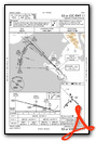

Departure Procedure (DP) Charts
Nearby Airports with Instrument Procedures
| ID | Name | Heading / Distance | ||
|---|---|---|---|---|
 |
CYDB | Burwash Airport | 009° | 113.8 |
Airport Images
Do you have a recent image of this airport? Upload it here!


