Login
Register


RPVJ
Masbate Airport
VFR Chart of RPVJ
Sectional Charts at SkyVector.com
IFR Chart of RPVJ
Enroute Charts at SkyVector.com
Location Information for RPVJ
Coordinates: N12°22.16' / E123°37.79'View all Airports in Masbate, Philippines.
Elevation is 50.0 feet MSL.
Operations Data
|
|
Airport Communications
| MASBATE RADIO Flight Service Station: | 122.00 |
|---|---|
| MASBATE RADIO Flight Service Station: | 3834.00 |
Nearby Navigation Aids
|
| ||||||||||||||||||||||||||||||||||||||||||||||||||||||||||||


Runway 04/22
| Dimensions: | 4199 x 98 feet / 1280 x 30 meters | |
|---|---|---|
| Surface: | Hard | |
| Runway 04 | Runway 22 | |
| Coordinates: | N12°21.91' / E123°37.59' | N12°22.46' / E123°38.02' |
| Elevation: | 53 | 17 |
| Runway Heading: | 039° | 219° |
Nearby Airports with Instrument Procedures
| ID | Name | Heading / Distance | ||
|---|---|---|---|---|
 |
RPLK | Bicol Airport | 003° | 44.5 |
|
RPLP | Legazpi Principal (Class 1) Airport | 007° | 47.5 |
|
RPVR | Roxas Principal Airport | 228° | 69.2 |
|
RPUN | Naga Principal Airport | 343° | 75.6 |
|
RPUV | Virac Airport | 024° | 79.6 |
|
RPVK | Kalibo International Airport | 240° | 84.5 |
|
RPVE | Godofredo P.Ramos Principal Airport | 255° | 101.8 |
|
RPVB | Bacolod Principal Airport | 200° | 101.7 |
|
RPVA | Daniel Z Romualdez Airport | 129° | 106.9 |
|
RPVI | Iloilo International Airport | 216° | 113.6 |
Airport Images
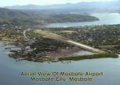
By: kyukyu


