Login
Register
SBBI
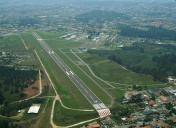
Bacacheri Airport
VFR Chart of SBBI
Sectional Charts at SkyVector.com
IFR Chart of SBBI
Enroute Charts at SkyVector.com
Location Information for SBBI
Coordinates: S25°24.20' / W49°14.02'View all Airports in Paraná, Brazil.
Elevation is 3059.0 feet MSL.
Operations Data
|
|
Airport Communications
| CURITIBA/BACACHERI ATIS: | 132.32 |
|---|---|
| SOLO BACACHERI Ground Control: | 121.80 |
| TORRE BACACHERI Tower: | 118.90 |
Nearby Navigation Aids
|
| ||||||||||||||||||||||||||||||||||||||||||||||||||||||||||||
Runway 18/36
| Dimensions: | 4560 x 102 feet / 1390 x 31 meters | |
|---|---|---|
| Surface: | Hard | |
| Runway 18 | Runway 36 | |
| Coordinates: | S25°24.10' / W49°14.00' | S25°24.65' / W49°13.77' |
| Elevation: | 3029 | 3058 |
| Runway Heading: | 178° | 358° |
| Displaced Threshold: | 984 Feet | |
Nearby Airports with Instrument Procedures
| ID | Name | Heading / Distance | ||
|---|---|---|---|---|
 |
SBCT | Afonso Pena International Airport | 157° | 8.3 |
 |
SBPG | Comandante Antonio Amilton Ber Airport | 284° | 51.2 |
 |
SBJV | Lauro Carneiro De Loyola Airport | 154° | 54.4 |
 |
SBNF | Ministro Victor Konder International Airport | 160° | 93.7 |
 |
SBCD | Cacador Airport | 227° | 124.0 |
 |
SSGG | Aeroporto Regional De Guarapua Airport | 269° | 124.4 |
 |
SBJH | Sao Paulo Catarina Aeroporto E Airport | 044° | 163.7 |
 |
SBSP | Congonhas Airport | 053° | 176.6 |
 |
SBST | Santos Airport | 061° | 183.0 |
 |
SBMG | Silvio Name Junior Airport | 306° | 190.7 |
 |
SBGR | Guarulhos-Gov Andre F Montoro Airport | 052° | 191.6 |


