Login
Register


SBBR
Presidente Juscelino Kubitsch Airport
VFR Chart of SBBR
Sectional Charts at SkyVector.com
IFR Chart of SBBR
Enroute Charts at SkyVector.com
Location Information for SBBR
Coordinates: S15°52.27' / W47°55.12'View all Airports in Distrito Federal, Brazil.
Elevation is 3498.0 feet MSL.
Operations Data
|
|
Airport Communications
| BRASILIA CONTROL Approach: | 120.00 |
|---|---|
| BRASILIA CONTROL Approach: | 119.20 |
| BRASILIA CONTROL Approach: | 119.50 |
| BRASILIA CONTROL Approach: | 119.70 |
| BRASILIA CONTROL Approach: | 120.30 |
| BRASILIA CONTROL Approach: | 120.65 |
| BRASILIA CONTROL Approach: | 121.15 |
| BRASILIA CONTROL Approach: | 128.82 |
| BRASILIA CONTROL Approach: | 129.15 |
| BRASILIA CONTROL Approach: | 129.32 |
| BRASILIA CONTROL Approach: | 129.60 |
| BRASILIA CONTROL Approach: | 129.72 |
| BRASILIA ATIS ATIS: | 127.80 |
| BRASILIA CLEARANCE Clearance Delivery: | 121.00 |
| BRASILIA Emergency: | 121.50 |
| BRASILIA GROUND Ground Control: | 121.80 |
| BRASILIA GROUND Ground Control: | 121.95 |
| BRASILIA OPERATIONS Operations: | 121.00 |
| BRASILIA OPERATIONS Operations: | 122.50 |
| BRASILIA OPERATIONS Operations: | 135.85 |
| BRASILIA TOWER Tower: | 118.10 |
| BRASILLA TOWER Tower: | 118.45 |
| BRASILIA TOWER Tower: | 118.75 |
Nearby Navigation Aids
|
| ||||||||||||||||||||||||||||||||||||||||||


Runway 11R/29L
| Dimensions: | 10827 x 148 feet / 3300 x 45 meters | |
|---|---|---|
| Surface: | Hard | |
| Runway 11R | Runway 29L | |
| Coordinates: | S15°52.84' / W47°56.40' | S15°52.73' / W47°54.64' |
| Elevation: | 3498 | 3418 |
| Runway Heading: | 108° | 288° |
| Displaced Threshold: | 492 Feet | |
Runway 11L/29R
| Dimensions: | 10499 x 148 feet / 3200 x 45 meters | |
|---|---|---|
| Surface: | Unknown | |
| Runway 11L | Runway 29R | |
| Coordinates: | S15°51.81' / W47°55.65' | S15°51.70' / W47°53.95' |
| Elevation: | 3448 | 3480 |
| Runway Heading: | 108° | 288° |
| Displaced Threshold: | 492 Feet | |
Nearby Airports with Instrument Procedures
| ID | Name | Heading / Distance | ||
|---|---|---|---|---|
 |
SBAN | Campo Marechal Marcio De Souza Airport | 250° | 64.7 |
|
SBGO | Santa Genoveva - International Airport | 238° | 87.9 |
|
SBCN | Caldas Novas Airport | 199° | 117.7 |
Airport Images
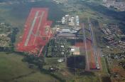
By: Ramon Schaeffer
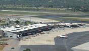
By: Lucas2013AFA


