Login
Register


SBBU
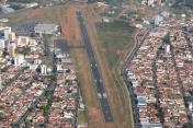
Bauru Airport
VFR Chart of SBBU
Sectional Charts at SkyVector.com
IFR Chart of SBBU
Enroute Charts at SkyVector.com
Location Information for SBBU
Coordinates: S22°20.62' / W49°3.23'View all Airports in São Paulo, Brazil.
Elevation is 2025.0 feet MSL.
Operations Data
|
|
Airport Communications
| BAURU ATIS: | 127.87 |
|---|---|
| RADIO BAURU Information: | 121.30 |
Nearby Navigation Aids
|
| ||||||||||||||||||||||||||||||||||||||||||||||||||||||||||||


Runway 14/32
| Dimensions: | 4925 x 115 feet / 1501 x 35 meters | |
|---|---|---|
| Surface: | Hard | |
| Runway 14 | Runway 32 | |
| Coordinates: | S22°20.53' / W49°3.50' | S22°20.92' / W49°2.85' |
| Elevation: | 2010 | 2022 |
| Runway Heading: | 145° | 325° |
| Displaced Threshold: | 640 Feet | |
Nearby Airports with Instrument Procedures
| ID | Name | Heading / Distance | ||
|---|---|---|---|---|
 |
SBAE | Bauru-Arealva Airport | 355° | 11.1 |
|
SBML | Frank Miloye Milenkovich Airport | 280° | 49.4 |
|
SBGP | Embraer-Unidade Gaviao Peixoto Airport | 046° | 50.1 |
|
SDMY | Fazenda Cambuhy Airport | 037° | 53.2 |
|
SWXQ | Lins Airport | 317° | 55.5 |
|
SBAQ | Bartolomeu De Gusmao Airport | 057° | 60.3 |
|
SBSR | Prof. Eriberto Manoel Reino Airport | 347° | 93.4 |
|
SBYS | Campo Fontenelle Airport | 077° | 97.6 |
|
SBRP | Leite Lopes Airport | 044° | 101.5 |
|
SBAU | Aracatuba Airport | 312° | 105.0 |
|
SBKP | Viracopos International Airport | 110° | 113.7 |
|
SBJH | Sao Paulo Catarina Aeroporto E Airport | 122° | 123.0 |
Airport Images
By: Ramon Schaeffer

By: Matheus Moraes


Comments
VOR BRU - BAURU
VOR U/S - REMOVED MANY YEARS AGO.
Matheus Andrade de Moraes