Login
Register


SBFL
Hercilio Luz Airport
VFR Chart of SBFL
Sectional Charts at SkyVector.com
IFR Chart of SBFL
Enroute Charts at SkyVector.com
Location Information for SBFL
Coordinates: S27°40.22' / W48°33.15'View all Airports in Santa Catarina, Brazil.
Elevation is 17.0 feet MSL.
Operations Data
|
|
Airport Communications
| FLORIANOPOLIS CONTROL Approach: | 119.65 |
|---|---|
| FLORIANOPOLIS CONTROL Approach: | 128.95 |
| FLORIANOPOLIS CONTROL Approach: | 129.45 |
| FLORIANOPOLIS ATIS: | 127.45 |
| FLORIANOPOLIS Emergency: | 121.50 |
| FLORIANOPOLIS GROUND Ground Control: | 121.70 |
| FLORIANOPOLIS OPERATIONS Operations: | 122.50 |
| FLORIANOPOLIS TOWER Tower: | 118.70 |
| FLORIANOPOLIS TOWER Tower: | 122.80 |
Nearby Navigation Aids
|
| ||||||||||||||||||||||||||||||||||||||||||


Runway 14/32
| Dimensions: | 7874 x 148 feet / 2400 x 45 meters | |
|---|---|---|
| Surface: | Hard | |
| Runway 14 | Runway 32 | |
| Coordinates: | S27°39.94' / W48°33.07' | S27°40.62' / W48°31.82' |
| Elevation: | 16 | 14 |
| Runway Heading: | 142° | 322° |
Runway 03/21
| Dimensions: | 4331 x 148 feet / 1320 x 45 meters | |
|---|---|---|
| Surface: | Unknown | |
| Runway 03 | Runway 21 | |
| Coordinates: | S27°40.51' / W48°33.25' | S27°39.88' / W48°33.11' |
| Elevation: | 16 | 16 |
| Runway Heading: | 032° | 212° |
| Displaced Threshold: | 459 Feet | |
Nearby Airports with Instrument Procedures
| ID | Name | Heading / Distance | ||
|---|---|---|---|---|
 |
SBNF | Ministro Victor Konder International Airport | 353° | 47.7 |
|
SBJA | Regional Sul Airport | 203° | 65.9 |
|
SSIM | Forquilhinha - Criciuma Airport | 215° | 78.1 |
|
SBJV | Lauro Carneiro De Loyola Airport | 351° | 87.6 |
|
SBLJ | Lages Airport | 265° | 92.3 |
|
SNCP | Aeroporto Regional Do Planalto Airport | 270° | 96.2 |
|
SBCD | Cacador Airport | 291° | 138.1 |
|
SBCX | Hugo Cantergiani Airport | 236° | 166.7 |
Airport Images
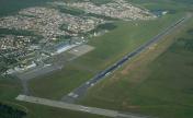
By: Ramon Schaeffer


