Login
Register


SBFZ
Pinto Martins International Airport
VFR Chart of SBFZ
Sectional Charts at SkyVector.com
IFR Chart of SBFZ
Enroute Charts at SkyVector.com
Location Information for SBFZ
Coordinates: S3°46.55' / W38°31.93'View all Airports in Ceará, Brazil.
Elevation is 82.0 feet MSL.
Operations Data
|
|
Airport Communications
| FORTALEZA CONTROL Approach: | 120.50 |
|---|---|
| FORTALEZA CONTROL Approach: | 133.00 |
| FORTALEZA CONTROL Approach: | 134.55 |
| FORTALEZA INTL ATIS: | 127.70 |
| FORTALEZA Emergency: | 121.50 |
| FORTALEZA GROUND Ground Control: | 121.95 |
| FORTALEZA OPERATIONS Operations: | 122.50 |
| FORTALEZA TOWER Tower: | 129.00 |
Nearby Navigation Aids
|
| ||||||||||||||||||||||||

Runway 13/31
| Dimensions: | 9039 x 148 feet / 2755 x 45 meters | |
|---|---|---|
| Surface: | Hard | |
| Runway 13 | Runway 31 | |
| Coordinates: | S3°46.40' / W38°32.62' | S3°46.77' / W38°31.25' |
| Elevation: | 82 | 63 |
| Runway Heading: | 126° | 306° |
| Displaced Threshold: | 466 Feet | |
Nearby Airports with Instrument Procedures
| ID | Name | Heading / Distance | ||
|---|---|---|---|---|
 |
SBAC | Regional De Aracati Airport | 137° | 64.4 |
|
SBMS | Dix Sept Rosado Airport | 140° | 110.0 |
|
SBJE | Comandante Ariston Pessoa Airport | 295° | 121.2 |
Airport Images
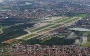
By: Ramon Schaeffer


Comments
LOCALIZER FREQUENCY
X-Plane files Localizer freq for ILS13 @ 109.30