Login
Register
SLAS
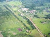
Ascencion De Guarayos Airport
VFR Chart of SLAS
Sectional Charts at SkyVector.com
IFR Chart of SLAS
Enroute Charts at SkyVector.com
Location Information for SLAS
Coordinates: S15°55.97' / W63°9.37'View all Airports in El Beni, Bolivia.
Elevation is 801.0 feet MSL.
Operations Data
|
|
Airport Communications
| RADIO ASCENSION Radio: | 6622.00 |
|---|---|
| TORRE ASCENCION Tower: | 118.10 |
Nearby Navigation Aids
|
| ||||||||||||||||||||||||
Runway 17/35
| Dimensions: | 4593 x 98 feet / 1400 x 30 meters | |
|---|---|---|
| Surface: | Soft | |
| Runway 17 | Runway 35 | |
| Coordinates: | S15°55.63' / W63°9.48' | S15°56.34' / W63°9.20' |
| Elevation: | 794 | 801 |
| Runway Heading: | 172° | 352° |
Nearby Airports with Instrument Procedures
| ID | Name | Heading / Distance | ||
|---|---|---|---|---|
 |
SLVR | Viru Viru International Airport | 179° | 102.4 |
 |
SLTR | Tte. Av. Jorge Henrich Arauz Airport | 302° | 121.9 |
 |
SLSV | San Ignacio De Velasco Airport | 103° | 125.0 |
 |
SLHI | Chimore Airport | 241° | 130.5 |


