Login
Register


SMZO
Paramaribo/Zorg En Hoop Airport
VFR Chart of SMZO
Sectional Charts at SkyVector.com
IFR Chart of SMZO
Enroute Charts at SkyVector.com
Location Information for SMZO
Coordinates: N5°48.67' / W55°11.62'View all Airports in Paramaribo, Suriname.
Elevation is 10.0 feet MSL.
Operations Data
|
|
Airport Communications
| ZORG EN HOOP Tower: | 118.70 |
|---|
Nearby Navigation Aids
|
| ||||||||||||||||||||||||||||||||||||


Runway 11/29
| Dimensions: | 1804 x 59 feet / 550 x 18 meters | |
|---|---|---|
| Surface: | Unknown | |
| Runway 11 | Runway 29 | |
| Coordinates: | N5°48.67' / W55°11.62' | N5°48.65' / W55°11.38' |
| Elevation: | 7 | 9 |
| Runway Heading: | 110° | 290° |
| Displaced Threshold: | 328 Feet | |
Nearby Airports with Instrument Procedures
| ID | Name | Heading / Distance | ||
|---|---|---|---|---|
 |
SMJP | J. A. Pengel International Airport | 181° | 21.5 |
|
SOCA | Cayenne Felix Eboue Airport | 109° | 179.5 |
|
SYEC | Eugene F Correia International Airport | 288° | 184.0 |
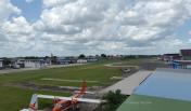
Airport Images

By: Akash386
By: Akash386


Comments
airfield information
Date:25 FEB 2019
SMZO Zorg & Hoop Tower Frequencies: Primary 120.1 Mhz / Backup 118.7Mhz
Var: 17°W (18° is published on the latest Insturment approach charts for SMJP)
Runway Surface: HARD
RWY 11 declared distances:
TORA:750m / 2460ft
LDA:550m /1804ft
displaced threshold = approximately 200m / 656ft
ASDA=840m /2755ft
stopway 90m / 295ft