Login
Register


UWKD
Kazan Airport
VFR Chart of UWKD
Sectional Charts at SkyVector.com
IFR Chart of UWKD
Enroute Charts at SkyVector.com
Location Information for UWKD
Coordinates: N55°36.42' / E49°16.82'View all Airports in Tatarstan, Russia.
Elevation is 410.0 feet MSL.
Operations Data
|
|
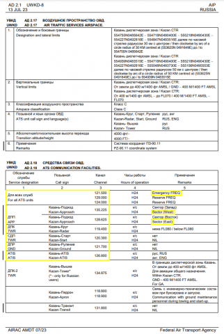
Airport Communications
| KAZAN - EAST Approach: | 128.62 |
|---|---|
| KAZAN - WEST Approach: | 135.22 |
| KAZAN ATIS: | 126.80 |
| KAZAN Emergency: | 121.50 |
| KAZAN Ground Control: | 121.70 |
| KAZAN Radar: | 119.40 |
| KAZAN Tower: | 120.30 |
Nearby Navigation Aids
|
| ||||||||||||||||||||||||||||||||||||||||||||||||||||||||||||


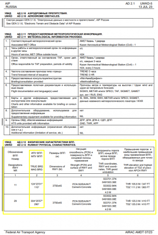
Runway 11/29
| Dimensions: | 12303 x 148 feet / 3750 x 45 meters | |
|---|---|---|
| Surface: | Hard | |
| Runway 11 | Runway 29 | |
| Coordinates: | N55°37.02' / E49°15.06' | N55°35.88' / E49°18.00' |
| Elevation: | 346 | 410 |
| Runway Heading: | 111° | 291° |
Nearby Airports with Instrument Procedures
| ID | Name | Heading / Distance | ||
|---|---|---|---|---|
 |
UWKS | Cheboksary Airport | 294° | 71.5 |
|
UWLW | Ulyanovsk/Vostochny Airport | 193° | 74.4 |
|
UWKJ | Yoshkar-Ola Airport | 325° | 80.7 |
|
UWLL | Ulyanovsk/Baratayevka Airport | 204° | 88.2 |
|
UWKE | Nizhnekamsk/Begishevo Airport | 090° | 95.8 |
Airport Images
Do you have a recent image of this airport? Upload it here!


Comments
AIRPORT INFORMATION CORRECTIONS
Hello! Please change information according with AIP of Russia.
Airport Communications:
KAZAN - EAST Approach: 128.62 - Change to: KAZAN APPROACH (EAST): 128.625
KAZAN - WEST Approach: 135.22 - Change to: KAZAN APPROACH (WEST): 135.225
KAZAN RADAR: 119.400
KAZAN Tower: 120.30 - Change to: KAZAN START: 120.300
KAZAN Ground Control: 121.70 - Change to: KAZAN GROUND: 121.700
KAZAN ATIS: 126.800
RESERVE FREQUENCY: 124.000, 129.000
EMERGENCY FREQUENCY: 121.500
Runway 11/29:
Runway 11:
Runway Heading: 111° - Change to: Runway Heading: 110°
Runway 29:
Runway Heading: 291° - Change to: Runway Heading: 290°
AIP