Login
Register


VDSV
Sihanouk International Airport
VFR Chart of VDSV
Sectional Charts at SkyVector.com
IFR Chart of VDSV
Enroute Charts at SkyVector.com
Location Information for VDSV
Coordinates: N10°34.48' / E103°38.05'View all Airports in Krong Preah Sihanouk, Cambodia.
Elevation is 10.0 feet MSL.
Operations Data
|
|
Airport Communications
| SIHANOUK APPROACH Approach: | 124.00 |
|---|---|
| SIHANOUK ATIS: | 128.50 |
| SIHANOUK TOWER Tower: | 118.20 |
Nearby Navigation Aids
|
| ||||||||||||||||||||||||||||||||||||||||||||||||||||||||||||


Runway 03/21
| Dimensions: | 10827 x 148 feet / 3300 x 45 meters | |
|---|---|---|
| Surface: | Hard | |
| Runway 03 | Runway 21 | |
| Coordinates: | N10°33.56' / E103°37.55' | N10°35.08' / E103°38.37' |
| Elevation: | 9 | 9 |
| Runway Heading: | 028° | 208° |
| Displaced Threshold: | 413 Feet | |
Nearby Airports with Instrument Procedures
| ID | Name | Heading / Distance | ||
|---|---|---|---|---|
 |
VVPQ | Kien Giang/Phu Quoc Airport | 138° | 32.2 |
|
VDPP | Phnom Penh International Airport | 050° | 92.0 |
|
VVRG | Kien Giang/Rach Gia Airport | 112° | 96.1 |
|
VVCM | Ca Mau Airport | 132° | 123.7 |
|
VVCT | Can Tho International Airport | 103° | 126.2 |
|
VTBO | Trat Airport | 322° | 127.7 |
|
VVCS | Vung Tau/Con Son Airport | 121° | 208.8 |
Airport Images
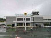
By: seeds007

By: mcantsin


