Login
Register


ZSWZ
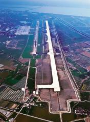
Wenzhou/Longwan Airport
VFR Chart of ZSWZ
Sectional Charts at SkyVector.com
IFR Chart of ZSWZ
Enroute Charts at SkyVector.com
Location Information for ZSWZ
Coordinates: N27°54.60' / E120°51.20'View all Airports in Zhejiang, China.
Elevation is 16.0 feet MSL.
Operations Data
|
|
Airport Communications
| WENZHOU APPROACH Approach: | 119.62 |
|---|---|
| WENZHOU APPROACH Approach: | 120.25 |
| WENZHOU APPROACH Approach: | 127.97 |
| WENZHOU APPROACH Approach: | 132.15 |
| WENZHOU/LONGWAN ATIS: | 127.05 |
| WENZHOU/LONGWAN Emergency: | 121.50 |
| WENZHOU GROUND Ground Control: | 121.85 |
| WENZHOU TOWER Tower: | 118.20 |
| WENZHOU TOWER Tower: | 118.87 |
Nearby Navigation Aids
|
| ||||||||||||||||||||||||||||||||||||||||||||||||||||||||||||


Runway 03/21
| Dimensions: | 10499 x 148 feet / 3200 x 45 meters | |
|---|---|---|
| Surface: | Hard | |
| Runway 03 | Runway 21 | |
| Coordinates: | N27°53.84' / E120°50.74' | N27°55.36' / E120°51.66' |
| Elevation: | 17 | 17 |
| Runway Heading: | 032° | 212° |
Nearby Airports with Instrument Procedures
| ID | Name | Heading / Distance | ||
|---|---|---|---|---|
 |
ZSYW | Yiwu/Yiwu Airport | 333° | 96.1 |
|
RCMT | Beigan Airport | 204° | 110.7 |
|
RCFG | Matsu/Nangan Airport | 204° | 115.2 |
|
ZSNB | Ningbo/Lishe Airport | 015° | 119.1 |
|
ZSFZ | Fuzhou/Changle Airport | 208° | 134.3 |
|
ZSTX | Huangshan/Tunxi Airport | 309° | 175.1 |