Login
Register


SNP
St Paul Island Airport
Official FAA Data Effective 2025-02-20 0901Z
Chart Supplement

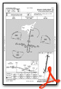
VFR Chart of PASN
Sectional Charts at SkyVector.com
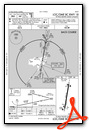
IFR Chart of PASN
Enroute Charts at SkyVector.com
Location Information for PASN
Coordinates: N57°9.98' / W170°13.35'Located 03 miles NE of St Paul Island, Alaska on 413 acres of land. View all Airports in Alaska.
Surveyed Elevation is 66 feet MSL.
Operations Data
|
|
Airport Communications
| ASOS: | 135.75 Tel. 907-546-2324 |
|---|---|
| CTAF: | 122.300 |
| ASOS at PBV (40.0 SE): | 135.45 907-859-2700 |
- APCH/DEP SVC PRVDD BY ANCHORAGE ARTCC ON FREQS 119.1/339.8 (SAINT PAUL ISLAND RCAG).
Nearby Navigation Aids
|
| ||||||||||||||||||||||||||||||||||||


Runway 18/36
| Dimensions: | 6500 x 150 feet / 1981 x 46 meters 1000 FT SAFETY AREA ON N & S END. | |
|---|---|---|
| Surface: | Asphalt / Grooved in Good Condition | |
| Edge Lighting: | High Intensity | |
| Runway 18 | Runway 36 | |
| Coordinates: | N57°10.50' / W170°13.19' | N57°9.45' / W170°13.52' |
| Elevation: | 66.2 | 39.5 |
| Traffic Pattern: | Left | Right |
| Runway Heading: | 190° True | 10° True |
| Markings: | Precision Instrument in good condition. | Precision Instrument in good condition. |
| Glide Slope Indicator | P4R (3.00° Glide Path Angle) | P4L (3.00° Glide Path Angle) |
| Approach Lights: | MALSF 1,400 Foot Medium-intensity Approach Lighting System with sequenced flashers. | MALSF 1,400 Foot Medium-intensity Approach Lighting System with sequenced flashers. |
| Obstacles: | 15 ft Road 200 ft from runway 15 FT ROAD 0 - 200 FT FM RWY END BOTH SIDES OF CNTRLN. |
8 ft Fence 460 ft from runway, 520 ft right of center |
Services Available
| Fuel: | Jet-A |
|---|---|
| Transient Storage: | NONE |
| Airframe Repair: | NOT AVAILABLE |
| Engine Repair: | NOT AVAILABLE |
| Bottled Oxygen: | NOT AVAILABLE |
| Bulk Oxygen: | NOT AVAILABLE |
Ownership Information
| Ownership: | Publicly owned | |
|---|---|---|
| Owner: | ALASKA DOT&PF SOUTHCOAST REGION | |
| PO BOX 112506 | ||
| JUNEAU, AK 99811-2506 | ||
| 907-465-1779 | ||
| Manager: | DALE RUCKMAN | |
| PO BOX 920525 | ||
| DUTCH HARBOR, AK 99692 | ||
| 907-581-1786 | OR 907-546-5000. | |
Other Remarks
- AVOID FLT BLW 1000 FT MAY 14 - SEP 14 IN AREAS WITH ACTIVE BIRD POPULATIONS & OTR TIMES IN AREAS WITH COASTAL SEAL ROOKERIES.
- WX BLN LAUNCH FAC ON ARPT, SEE INSIDE BACK COVER FOR OPRN DETAILS.
- 625 FT LGTD TWR 1 MI SW.
- WX CAMERA AVBL ON INTERNET AT HTTPS://WEATHERCAMS.FAA.GOV
- THREE 100 FT WIND TURBINES 1/4 MI SW OF APCH END. 45 FT LGTD TWR 350 FT W 1000 FT N.
- ACTVT MALSF RWY 18 & 36; PAPI RWY 18 & 36; HIRL RWY 18/36- CTAF.
Weather Minimums
Instrument Approach Procedure (IAP) Charts
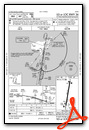
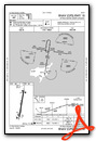
Nearby Airports with Instrument Procedures
| ID | Name | Heading / Distance | ||
|---|---|---|---|---|
 |
PAPB | St George Airport | 152° | 39.9 |
Airport Images
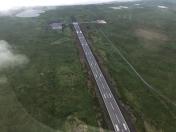
By: SPF

By: SPF


