Login
Register
LGKC
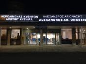
Alexandros Aristotelous Onassi Airport
VFR Chart of LGKC
Sectional Charts at SkyVector.com
IFR Chart of LGKC
Enroute Charts at SkyVector.com
Location Information for LGKC
Coordinates: N36°16.45' / E23°1.00'View all Airports in Attiki, Greece.
Elevation is 1045.0 feet MSL.
Operations Data
|
|
Airport Communications
| KITHIRA INFORMATION Information: | 123.25 |
|---|
Nearby Navigation Aids
|
| ||||||||||||||||||||||||||||||||||||||||||||||||||||||||||||
Runway 02/20
| Dimensions: | 4793 x 98 feet / 1461 x 30 meters | |
|---|---|---|
| Surface: | Hard | |
| Runway 02 | Runway 20 | |
| Coordinates: | N36°16.09' / E23°0.79' | N36°16.80' / E23°1.22' |
| Elevation: | 1045 | 1043 |
| Runway Heading: | 023° | 203° |
Nearby Airports with Instrument Procedures
| ID | Name | Heading / Distance | ||
|---|---|---|---|---|
 |
LGKL | Kalamata Airport | 315° | 67.5 |
 |
LGSA | Ioannis Daskalogiannis Airport | 128° | 71.0 |
 |
LGML | Milos Airport | 069° | 75.1 |
 |
LGAV | Eleftherios Venizelos Airport | 023° | 109.1 |
 |
LGEL | Elefsis Airport | 013° | 110.6 |
 |
LGTT | Dekelia Tatoi Airport | 017° | 115.6 |
 |
LGSR | Santorini Airport | 085° | 119.6 |
 |
LGIR | Nikos Kazantzakis Airport | 117° | 119.5 |
 |
LGMK | Mikonos Airport | 057° | 132.1 |
 |
LGZA | Dionisios Solomos Airport | 311° | 135.4 |
 |
LGRX | Araxos Airport | 326° | 135.9 |
 |
LGKF | Anna Pollatou Airport | 313° | 163.6 |


Comments
KITHIRA AIRPORT CORRECTION UPDATE NAME
Dear all
please note that correction Iata name is Kithira/Alexandros A. Onassis insted of kihtira/Alexandros Aristotelo Airport .
Please reviw and recorrect name
best regards
zacharias souris
Pages