Login
Register
LPBR
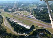
Braga Airport
VFR Chart of LPBR
Sectional Charts at SkyVector.com
IFR Chart of LPBR
Enroute Charts at SkyVector.com
Location Information for LPBR
Coordinates: N41°35.22' / W8°26.71'View all Airports in Braga, Portugal.
Elevation is 246.0 feet MSL.
Operations Data
|
|
Airport Communications
| PORTO APPROACH Approach: | 120.91 |
|---|
Nearby Navigation Aids
|
| ||||||||||||||||||||||||||||||||||||||||||||||||||||||||||||
Runway 07/25
| Dimensions: | 3117 x 82 feet / 950 x 25 meters | |
|---|---|---|
| Surface: | Hard | |
| Runway 07 | Runway 25 | |
| Coordinates: | N41°35.10' / W8°27.01' | N41°35.34' / W8°26.41' |
| Elevation: | 236 | 240 |
| Runway Heading: | 067° | 247° |
Nearby Airports with Instrument Procedures
| ID | Name | Heading / Distance | ||
|---|---|---|---|---|
 |
LPPR | Porto Airport | 206° | 23.6 |
 |
LEVX | Vigo Airport | 348° | 39.4 |
 |
LEST | Santiago/ Rosalia De Castro Airport | 000° | 78.5 |
 |
LECO | A Coruna Airport | 001° | 102.9 |
 |
LELN | Leon Airport | 063° | 138.3 |
 |
LESA | Salamanca Airport | 104° | 138.5 |
 |
LEAS | Asturias Airport | 041° | 159.6 |


