Login
Register
FYWB
Walvis Bay Airport
VFR Chart of FYWB
Sectional Charts at SkyVector.com
IFR Chart of FYWB
Enroute Charts at SkyVector.com
Location Information for FYWB
Coordinates: S22°58.80' / E14°38.72'View all Airports in Erongo, Namibia.
Elevation is 299.0 feet MSL.
Operations Data
|
|
Airport Communications
| WALVIS BAY Approach: | 122.50 |
|---|---|
| WALVIS BAY ATIS: | 127.00 |
| WALVIS BAY Ground Control: | 121.75 |
| WALVIS BAY Tower: | 122.50 |
Nearby Navigation Aids
|
| ||||||||||||||||||||||||
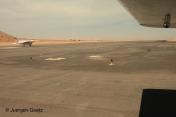
Runway 09/27
| Dimensions: | 6959 x 197 feet / 2121 x 60 meters | |
|---|---|---|
| Surface: | Hard | |
| Runway 09 | Runway 27 | |
| Coordinates: | S22°58.97' / E14°38.13' | S22°58.62' / E14°39.31' |
| Elevation: | 235 | 316 |
| Runway Heading: | 085° | 265° |
Nearby Airports with Instrument Procedures
| ID | Name | Heading / Distance | ||
|---|---|---|---|---|
 |
FYWE | Windhoek Eros Airport | 081° | 136.8 |
 |
FYWH | Hosea Kutako Int/Windhoek Airport | 079° | 159.6 |


Comments
The length of the upgraded
The length of the upgraded runway is 3487 meters or 11,450 feet.
Width is approx 60 meters.
See Bing maps or Google Earth.
Hindsight is what you see from the tailgunner's position.