Login
Register
08VA
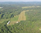
Springwood Airstrip Gliderport
Official FAA Data Effective 2026-01-22 0901Z
VFR Chart of 08VA
Sectional Charts at SkyVector.com
IFR Chart of 08VA
Enroute Charts at SkyVector.com
Location Information for 08VA
Coordinates: N37°33.24' / W79°44.94'Located 05 miles NW of Buchanan, Virginia on 8 acres of land. View all Airports in Virginia.
Estimated Elevation is 1026 feet MSL.
Operations Data
|
|
Airport Communications
| CTAF: | 122.900 |
|---|---|
| ATIS at ROA (17.5 SW): | 132.375 |
| ASOS at ROA (17.8 SW): | 540-216-0158 |
| AWOS-3 at HSP (24.3 N): | 118.8 540-839-5974 |
Nearby Navigation Aids
|
| ||||||||||||||||||||||||||||||||||||||||||||||||||||||||||||
Runway 09/27
DEP WILL BE ON RWY 09; APCH AND LANDING ON RWY 27. | ||
| Dimensions: | 1200 x 50 feet / 366 x 15 meters | |
|---|---|---|
| Surface: | Turf | |
| Runway 09 | Runway 27 | |
| Coordinates: | N37°33.23' / W79°45.07' | N37°33.25' / W79°44.82' |
| Elevation: | 1026.0 | 984.0 |
Ownership Information
| Ownership: | Privately Owned | |
|---|---|---|
| Owner: | WILLIAM STANFORD STEWART | |
| 331 INTERMONT FARM LANE | ||
| BUCHANAN, VA 24066 | ||
| 540-213-3035 | ||
| Manager: | WILLIAM SANFORD STEWART | |
| 331 INTERMONT FARM LANE | ||
| BUCHANAN, VA 24066 | ||
| 540-521-3035 | ||
Other Remarks
- FOR CD CTC ROANOKE APCH AT 540-563-1307.
Nearby Airports with Instrument Procedures
| ID | Name | Heading / Distance | ||
|---|---|---|---|---|
 |
KROA | Roanoke/Blacksburg Regional (Woodrum Field) Airport | 218° | 17.4 |
 |
KHSP | Ingalls Field Airport | 350° | 24.2 |
 |
W90 | New London Airport | 130° | 26.0 |
 |
W91 | Smith Mountain Lake Airport | 164° | 27.8 |
 |
KLYH | Lynchburg Regional/Preston Glenn Field Airport | 117° | 29.5 |
 |
W24 | Falwell Airport | 109° | 31.7 |
 |
KLWB | Greenbrier Valley Airport | 300° | 35.9 |
 |
KBCB | Virginia Tech/Montgomery Exec Airport | 237° | 37.8 |
 |
0V4 | Brookneal/Campbell County Airport | 124° | 42.9 |
 |
W13 | Eagle's Nest Airport | 050° | 49.5 |
 |
KPSK | New River Valley Airport | 240° | 51.0 |
 |
KMTV | Blue Ridge Airport | 193° | 56.8 |


