Login
Register
CAJ3
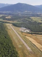
Creston Airport
VFR Chart of CAJ3
Sectional Charts at SkyVector.com
IFR Chart of CAJ3
Enroute Charts at SkyVector.com
Location Information for CAJ3
Coordinates: N49°2.20' / W116°29.88'View all Airports in British Columbia, Canada.
Elevation is 2094 feet MSL.
Magnetic Variation from 2014 is 15° East
Time Zone is UTC-7.
Operations Data
|
|
Customs Information
AOE/CAN
Airport Communications
| Remote Communications Outlet (RCO) | Pacific Radio 125.85 (FISE) 126.7 (bcst) |
|---|---|
| Aerodrome Traffic Frequency (ATF) | UNICOM 122.8 5NM 5100 ASL |
| AUTO | 129.175 |
Nearby Navigation Aids
|
| ||||||||||||||||||||||||||||||||||||||||||||||||||||||||||||
Runway 15/33
| Dimensions: | 3944 x 75 feet. | |
|---|---|---|
| Surface: | ||
| Remarks | ASPH Rwy 15 up 0.6% AGN IIIA | |
| Runway 15 | Runway 33 | |
| Runway Heading: | 155° | 335° |
| Glide Slope Indicator | PAPI for aircraft with eye-to-wheel height up to 10 feet. | PAPI for aircraft with eye-to-wheel height up to 10 feet. |
Runway Conditions Reporting Source
Operator Ltd win maint
Apron Information
Tran prkg and tie-downs NW of apron on grass. If unable to park on grass use NW
corner of apron. All parked acft must be secured using tie-downs. Designated Air
Ambulance prkg on E side btwn fuel farm and ambulance ramp.
Services Available
| Information | PN 250-428-2733 |
|---|---|
| Fuel Available | 100LL, JA (Cardlock, Visa & MasterCard) |
| Servicing Available | Extended Parking, Tie Downs |
Public Facilities
| Location | Facilities | Remarks |
|---|---|---|
| On Aerodrome | Telephone | |
| Within 5 NM | Food, Taxi, Medical Aid, Accomodations, Car Rental |
Flight Planning
| Flight Information Centre (FIC) | Kamloops 866-WXBRIEF (Toll free within Canada) or 866-541-4101 (Toll free within Canada & USA) |
|---|---|
| Weather (WX) | AUTO (See COMM) 250-402-6326 |
Aerodrome Operator
Creston Valley Reg Airport Society
250-428-2733 Reg
Nearby Airports with Instrument Procedures
| ID | Name | Heading / Distance | ||
|---|---|---|---|---|
 |
CYXC | Cranbrook/Canadian Rockies Airport | 023° | 44.5 |
 |
CYCZ | Fairmont Hot Springs Airport | 002° | 81.4 |
 |
CZPC | Pincher Creek Airport | 057° | 102.5 |
 |
CYLW | Kelowna Airport | 282° | 125.5 |
 |
CYVK | Vernon Airport | 289° | 132.2 |


Comments
AWOS (AUTO)
AWOS now capable of providing sky condition.
Courtesy car. Pilot's lounge.
Courtesy car. Pilot's lounge. Airport camping
Courtesy car.
Call 250-428-1961 for instructions re: courtesy car