Login
Register
CNP
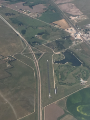
Billy G Ray Field Airport
Official FAA Data Effective 2025-12-25 0901Z
VFR Chart of KCNP
Sectional Charts at SkyVector.com
IFR Chart of KCNP
Enroute Charts at SkyVector.com
Location Information for KCNP
Coordinates: N41°4.65' / W102°27.84'Located 01 miles S of Chappell, Nebraska on 116 acres of land. View all Airports in Nebraska.
Estimated Elevation is 3681 feet MSL.
Operations Data
|
|
Airport Communications
| CTAF: | 122.900 |
|---|---|
| ASOS at SNY (23.7 W): | 125.775 308-254-3525 |
| AWOS-3 at HEQ (31.5 S): | 119.275 970-854-3679 |
| AWOS-3 at OGA (31.6 E): | 121.275 308-284-6573 |
- APCH/DEP CTL SVC PRVDD BY DENVER ARTCC (ZDV) ON FREQS 118.475/225.4 (BRUSH/B/ RCAG).
Nearby Navigation Aids
|
| ||||||||||||||||||||||||||||||||||||||||||||||||||||||||||||
Runway 12/30
| Dimensions: | 4000 x 55 feet / 1219 x 17 meters | |
|---|---|---|
| Surface: | Asphalt in Poor Condition SEVERE BLOCK CRACKING AND FOD THRU OUT PVMNT. | |
| Weight Limits: | 72 /F/D/Z/T, S-15 | |
| Edge Lighting: | Medium Intensity | |
| Runway 12 | Runway 30 | |
| Coordinates: | N41°4.86' / W102°28.18' | N41°4.44' / W102°27.51' |
| Elevation: | 3681.3 | 3677.8 |
| Traffic Pattern: | Left | Left |
| Runway Heading: | 130° True | 310° True |
| Displaced Threshold: | 130 Feet | |
| Markings: | Non-Precision Instrument in fair condition. | Non-Precision Instrument in fair condition. |
| Obstacles: | 30 ft Road 709 ft from runway, 288 ft right of center | 11 ft Road 371 ft from runway, 155 ft right of center APCH SLOPE 45:1 TO DSPLCD THLD. |
Services Available
| Fuel: | 100LL (blue) |
|---|---|
| Transient Storage: | Hangars,Tiedowns CALL FOR HANGAR AVBL 308-874-4350. |
| Airframe Repair: | NONE |
| Engine Repair: | NONE |
| Bottled Oxygen: | NONE |
| Bulk Oxygen: | NONE |
Ownership Information
| Ownership: | Publicly owned | |
|---|---|---|
| Owner: | CHAPPELL AIRPORT AUTHORITY | |
| PO BOX 546 | ||
| CHAPPELL, NE 69129-0546 | ||
| 308-874-2708 | ||
| Manager: | CHRIS RAY | |
| PO BOX 546 | ||
| CHAPPELL, NE 69129-0546 | ||
| 308-874-4350 | ||
Other Remarks
- THIS AIRPORT HAS BEEN SURVEYED BY THE NATIONAL GEODETIC SURVEY.
- FOR CD CTC DENVER ARTCC AT 303-651-4257.
- MIRL RWY 12/30 PRESET LOW INTST; TO INCR INTST ACTVT - CTAF.
Weather Minimums
Instrument Approach Procedure (IAP) Charts
Nearby Airports with Instrument Procedures
| ID | Name | Heading / Distance | ||
|---|---|---|---|---|
 |
KOKS | Garden County/King Rhiley Field Airport | 014° | 20.1 |
 |
KSNY | Sidney Municipal/Lloyd W Carr Field Airport | 273° | 23.7 |
 |
KOGA | Searle Field Airport | 085° | 31.6 |
 |
KHEQ | Holyoke Airport | 163° | 31.7 |
 |
KGGF | Grant Municipal Airport | 110° | 35.4 |
 |
KSTK | Sterling Municipal Airport | 232° | 45.8 |
 |
KIML | Imperial Municipal Airport | 131° | 51.3 |
 |
KIBM | Kimball Municipal/Robert E Arraj Field Airport | 277° | 55.4 |
 |
2V6 | Yuma Municipal Airport | 191° | 59.4 |
 |
2V5 | Wray Municipal Airport | 170° | 59.5 |
 |
KAIA | Alliance Municipal Airport | 345° | 60.5 |
 |
KAKO | Colorado Plains Regional Airport | 212° | 64.2 |


