Login
Register


CZBA
Burlington Executive Airport
VFR Chart of CZBA
Sectional Charts at SkyVector.com
IFR Chart of CZBA
Enroute Charts at SkyVector.com
Location Information for CZBA
Coordinates: N43°26.48' / W79°51.02'View all Airports in Ontario, Canada.
Elevation is 601 feet MSL.
Magnetic Variation from 2013 is 10° West
Time Zone is UTC-5(4).
Operations Data
|
|
Customs Information
AOE/CAN
Airport Communications
| Aerodrome Traffic Frequency (ATF) | UNICOM limited hours other times traffic 123.5 5NM below 2500 ASL |
|---|---|
| Terminal (TML) | Toronto 119.3 |
| AUTO | 122.55 |
Nearby Navigation Aids
|
| ||||||||||||||||||||||||||||||||||||||||||||||||||||||||||||


Runway 14/32
| Dimensions: | 3950 x 100 feet. | |
|---|---|---|
| Surface: | ||
| Remarks | ASPH Rwy 14 down 0.61% | |
| Runway 14 | Runway 32 | |
| Runway Heading: | 141º | 321º |
| Displaced Threshold: | 181 feet | 409 feet |
| Approach Lights | Runway ID Lights (Strobes) | Runway ID Lights (Strobes) |
| Glide Slope Indicator | APAPI - Abbreviated PAPI for aircraft with eye-to-wheel height up to 10 feet. | APAPI - Abbreviated PAPI for aircraft with eye-to-wheel height up to 10 feet. |
Runway 09/27
| Dimensions: | 2464 x 50 feet. | |
|---|---|---|
| Surface: | asphalt | |
| Remarks | Rwy 09 down 0.42% | |
| Runway 09 | Runway 27 | |
| Runway Heading: | 086° | 266° |
| Displaced Threshold: | 328 feet | 254 feet |
Runway Conditions Reporting Source
Operator 13-23Z or Spectrum Airways 905-336-4010
Services Available
| Fuel Available | 100LL, JA cardlock dispenser |
|---|---|
| Oil Available | 100 |
| Servicing Available | Storage, Minor Repairs, Major Repairs, Extended Parking, Tie Downs |
Public Facilities
| Location | Facilities | Remarks |
|---|---|---|
| Within 5 NM | Telephone, Food, Taxi, Medical Aid, Accomodations, Car Rental | 7 |
Flight Planning
| Flight Information Centre (FIC) | London 866-WXBRIEF (Toll free within Canada) or 866-541-4104 (Toll free within Canada & USA) |
|---|---|
| Weather (WX) | AUTO (see COMM) WxCam |
Aerodrome Operator
Vince Rossi 905-336-4010 (Day),
416-617-2428 (Night) Reg
Nearby Airports with Instrument Procedures
| ID | Name | Heading / Distance | ||
|---|---|---|---|---|
 |
CYHM | Hamilton Airport | 203° | 16.5 |
|
CYYZ | Toronto/Lester B. Pearson International Airport | 044° | 17.0 |
|
CYTZ | Toronto/Billy Bishop Toronto City Airport | 070° | 22.8 |
|
CYKF | Kitchener/Waterloo Airport | 283° | 23.1 |
|
CYFD | Brantford Airport | 239° | 28.4 |
|
CYSN | St Catharines/Niagara District Airport | 126° | 33.3 |
|
CYSA | Stratford Municipal Airport | 278° | 47.4 |
|
CYTB | Tillsonburg Airport | 242° | 50.0 |
|
CYOO | Toronto/Oshawa Executive Airport Airport | 064° | 50.6 |
|
CNV8 | Edenvale Airport | 005° | 60.0 |
|
CYXU | London Airport | 257° | 62.1 |
|
CNY3 | Collingwood Airport | 357° | 61.9 |
Airport Images
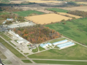
By: cboulos


