Login
Register


DRI
Beauregard Regional Airport
Official FAA Data Effective 2024-04-18 0901Z
Chart Supplement

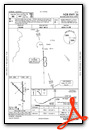
VFR Chart of KDRI
Sectional Charts at SkyVector.com
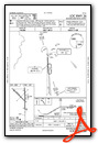
IFR Chart of KDRI
Enroute Charts at SkyVector.com
Location Information for KDRI
Coordinates: N30°49.90' / W93°20.39'Located 03 miles SW of De Ridder, Louisiana on 4300 acres of land. View all Airports in Louisiana.
Surveyed Elevation is 201 feet MSL.
Operations Data
|
|
Airport Communications
| AWOS-3PT: | 118.225 Tel. 337-463-8278 |
|---|---|
| POLK APPROACH: | 123.7 261.3 |
| POLK DEPARTURE: | 123.7 261.3 |
| CTAF: | 122.800 |
| UNICOM: | 122.800 |
| ATIS at POE (14.9 NE): | 134.85 |
| ASOS at POE (14.9 NE): | 134.85 337-531-4100 |
| AWOS-3PT at 5R8 (24.6 S): | 121.2 337-786-1518 |
Nearby Navigation Aids
|
| ||||||||||||||||||||||||||||||||||||||||||||||||||||||||||||


Runway 18/36
| Dimensions: | 5494 x 100 feet / 1675 x 30 meters | |
|---|---|---|
| Surface: | Asphalt-Concrete / Aggregate Friction Seal Coated in Good Condition | |
| Weight Limits: | S-60 | |
| Edge Lighting: | Medium Intensity | |
| Runway 18 | Runway 36 | |
| Coordinates: | N30°50.28' / W93°20.27' | N30°49.37' / W93°20.26' |
| Elevation: | 201.1 | 196.7 |
| Traffic Pattern: | Left | Left |
| Runway Heading: | 179° True | 359° True |
| Markings: | Non-Precision Instrument in poor condition. | Non-Precision Instrument in poor condition. |
| Glide Slope Indicator | P4R (3.00° Glide Path Angle) | P4L (3.00° Glide Path Angle) |
| Approach Lights: | ODALS Omnidirectional Approach Lighting System | |
| REIL: | Yes | |
| Obstacles: | 95 ft Trees 2437 ft from runway | 74 ft Trees 2169 ft from runway, 226 ft right of center |
Runway 14/32
| Dimensions: | 4218 x 60 feet / 1286 x 18 meters | |
|---|---|---|
| Surface: | Asphalt in Good Condition | |
| Runway 14 | Runway 32 | |
| Coordinates: | N30°50.25' / W93°20.85' | N30°49.76' / W93°20.28' |
| Elevation: | 191.5 | 192.8 |
| Runway Heading: | 134° True | 314° True |
| Displaced Threshold: | 454 Feet | |
| Markings: | Basic in fair condition. | Basic in fair condition. |
| Obstacles: | 81 ft Trees 1426 ft from runway, 163 ft right of center APCH SLP 20:1 TO DSPLCD THR. |
65 ft Trees 1635 ft from runway, 114 ft left of center |
Services Available
| Fuel: | 100LL (blue), Jet-A |
|---|---|
| Transient Storage: | Hangars,Tiedowns |
| Airframe Repair: | MINOR |
| Engine Repair: | MINOR |
| Bottled Oxygen: | NONE |
| Bulk Oxygen: | NONE |
| Other Services: | CROP DUSTING SERVICES,PILOT INSTRUCTION,PARACHUTE JUMP ACTIVITY,AIRCRAFT RENTAL |
Ownership Information
| Ownership: | Publicly owned | |
|---|---|---|
| Owner: | BEAUREGARD PARISH | |
| 1220 1ST AVE | ||
| DERIDDER, LA 70634 | ||
| 337-463-8250 | ||
| Manager: | SAM LACK | |
| 1220 1ST AVE | ||
| DERIDDER, LA 70634 | ||
| 337-463-8250 | ||
Operational Statistics
| Single Engine Aircraft Based on Field: | 22 | Statistics collected for 12 month period ending 2023-10-10 | |
|---|---|---|---|
| Multi-Engine Aircraft Based on Field: | 2 | Annual Commercial Operations: | none |
| Jet Aircraft Based on Field: | none | Annual Commuter Operations: | none |
| Helicopters Based on Field: | none | Annual Air Taxi Operations: | none |
| Military Aircraft Based on Field: | none | Annual Military Operations: | 1000 |
| Gliders Based on Field: | none | Annual GA Local Operations: | 7200 |
| Ultralights Based on Field: | none | Annual GA Itinerant Operations: | 6200 |
Other Remarks
- FOR CD IF UNA TO CTC ON FSS FREQ, CTC POLK APCH AT 337-531-2352.
- RUNWAY 18 MARKINGS FADED
- RUNWAY 36 MARKINGS FADED
- 0LL 100LL AVBL 24 HRS SELF SERVICE WITH CREDIT CARD. FOR JET A AFT HRS & HOLS CALL 337-401-2967.
- REIL RWY 18 AND MIRL RWY 18/36 PRESET LOW INTST DUSK-DAWN; TO INCR INTST ACTVT - CTAF.
Weather Minimums
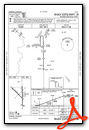
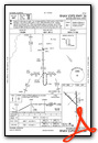
Instrument Approach Procedure (IAP) Charts
Nearby Airports with Instrument Procedures
| ID | Name | Heading / Distance | ||
|---|---|---|---|---|
 |
L39 | Leesville Airport | 359° | 20.1 |
|
5R8 | De Quincy Industrial Airpark Airport | 196° | 24.4 |
|
KACP | Allen Parish Airport | 098° | 34.0 |
|
KJAS | Jasper County/Bell Field Airport | 275° | 36.0 |
|
KCWF | Chennault International Airport | 164° | 38.6 |
|
KUXL | Southland Field Airport | 182° | 42.0 |
|
KLCH | Lake Charles Regional Airport | 171° | 42.7 |
|
3R4 | Hart Airport | 350° | 43.3 |
|
6R1 | Welsh Airport | 143° | 44.1 |
|
3R7 | Jennings Airport | 135° | 49.4 |
|
KAEX | Alexandria International Airport | 053° | 50.4 |
|
KORG | Orange County Airport | 207° | 51.6 |
Airport Images
Do you have a recent image of this airport? Upload it here!


