Login
Register
EBBN
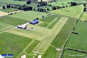
Bullingen Airport
VFR Chart of EBBN
Sectional Charts at SkyVector.com
IFR Chart of EBBN
Enroute Charts at SkyVector.com
Location Information for EBBN
Coordinates: N50°24.90' / E6°16.58'View all Airports in Wallonie, Belgium.
Elevation is 2059.0 feet MSL.
Operations Data
|
|
Airport Communications
| BULLINGEN Radio: | 118.98 |
|---|
Nearby Navigation Aids
|
| ||||||||||||||||||||||||||||||||||||||||||||||||||||||||||||
Runway
| Surface: | Soft | |
|---|---|---|
Nearby Airports with Instrument Procedures
| ID | Name | Heading / Distance | ||
|---|---|---|---|---|
 |
ETNN | Norvenich Airport | 030° | 28.9 |
 |
ETSB | Buchel Airport | 115° | 33.6 |
 |
ETNG | Geilenkirchen Airport | 344° | 34.0 |
 |
EBLG | Liege Airport | 292° | 34.6 |
 |
EHBK | Maastricht/Maastricht Aachen Airport | 327° | 35.6 |
 |
EDDK | Koeln/Bonn Airport | 050° | 42.8 |
 |
EDFH | Frankfurt-Hahn Airport | 126° | 47.3 |
 |
ELLX | Luxembourg Airport | 183° | 47.6 |
 |
EDLN | Moenchengladbach Airport | 009° | 49.7 |
 |
EBBL | Kleine-Brogel Airport | 326° | 54.7 |
 |
EDDL | Duesseldorf Airport | 019° | 55.1 |
 |
EHBD | Weert Budel Airport | 333° | 56.6 |


