Login
Register


GYB
Giddings-Lee County Airport
Official FAA Data Effective 2025-11-27 0901Z
Chart Supplement

VFR Chart of KGYB
Sectional Charts at SkyVector.com
IFR Chart of KGYB
Enroute Charts at SkyVector.com
Location Information for KGYB
Coordinates: N30°10.16' / W96°58.80'Located 03 miles W of Giddings, Texas on 84 acres of land. View all Airports in Texas.
Surveyed Elevation is 484 feet MSL.
Operations Data
|
|
Airport Communications
| AWOS-3: | 119.225 Tel. 979-542-0382 |
|---|---|
| AUSTIN APPROACH: | 127.225 317.65 |
| AUSTIN DEPARTURE: | 127.225 317.65 |
| CTAF: | 123.050 |
| UNICOM: | 123.050 |
| AWOS-3 at 3T5 (15.8 S): | 124.175 979-242-5777 |
| AWOS-3PT at RWV (25.2 NE): | 118.35 979-567-6784 |
| AWOS-3 at 11R (31.6 E): | 121.125 979-836-2303 |
Nearby Navigation Aids
|
| ||||||||||||||||||||||||||||||||||||||||||||||||||||||||||||


Runway 17/35
| Dimensions: | 4000 x 75 feet / 1219 x 23 meters | |
|---|---|---|
| Surface: | Asphalt in Good Condition | |
| Weight Limits: | S-12 | |
| Edge Lighting: | Medium Intensity | |
| Runway 17 | Runway 35 | |
| Coordinates: | N30°10.48' / W96°58.84' | N30°9.83' / W96°58.76' |
| Elevation: | 484.1 | 439.1 |
| Traffic Pattern: | Left | Left |
| Runway Heading: | 174° True | 354° True |
| Markings: | Non-Precision Instrument in good condition. | Non-Precision Instrument in good condition. |
| Glide Slope Indicator | P2L (3.75° Glide Path Angle) | P2L (3.40° Glide Path Angle) |
| Obstacles: | 44 ft Trees 520 ft from runway, 260 ft left of center 5 FT FENCE, 0-77 FT DSTC, 222 FT L. |
46 ft Trees 760 ft from runway |
Services Available
| Fuel: | 100LL (blue), Jet-A |
|---|---|
| Transient Storage: | Tiedowns |
| Airframe Repair: | MAJOR |
| Engine Repair: | MAJOR |
| Bottled Oxygen: | NONE |
| Bulk Oxygen: | NONE |
Ownership Information
| Ownership: | Publicly owned | |
|---|---|---|
| Owner: | CITY OF GIDDINGS & LEE CO | |
| 118 E RICHMOND | ||
| GIDDINGS, TX 78942 | ||
| 979-540-2710 | ||
| Manager: | KYLE WEISS | |
| 1234 CR 206 | ||
| GIDDINGS, TX 78942 | ||
| 979-542-6081 | MGR CELL 512-470-1466. | |
Other Remarks
- DEER ON & INVOF ARPT.
- FOR CD CTC AUSTIN APCH AT 512-369-7865.
- 0LL 100LL & JET A 24 HR SELF SERVE.
Weather Minimums

Instrument Approach Procedure (IAP) Charts


Nearby Airports with Instrument Procedures
| ID | Name | Heading / Distance | ||
|---|---|---|---|---|
 |
84R | Smithville Crawford Municipal Airport | 229° | 12.9 |
|
3T5 | Fayette Regional Air Center Airport | 174° | 15.7 |
|
KRWV | Caldwell Municipal Airport | 034° | 25.2 |
|
11R | Brenham Municipal Airport | 084° | 31.6 |
|
KEDC | Austin Exec Airport | 294° | 33.4 |
|
T74 | Taylor Municipal Airport | 315° | 34.1 |
|
KAUS | Austin-Bergstrom International Airport | 272° | 35.9 |
|
KCLL | Easterwood Field Airport | 051° | 40.7 |
|
50R | Lockhart Municipal Airport | 242° | 40.8 |
|
KLHB | Hearne Municipal Airport | 023° | 46.0 |
|
60R | Navasota Municipal Airport | 075° | 46.6 |
|
KCFD | Coulter Field Airport | 045° | 46.9 |
Airport Images
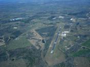
By: Luali


